North Atlantic · 18 Volcanic Islands · Puffins · Múlafossur
Faroe Islands
18 Emerald Islands in the North Atlantic — Múlafossur, Mykines Puffins, Saksun & Tórshavn
🇫🇴
⚡ Key Facts
🏛️
Tórshavn
Capital
👥
54,000
Population
📐
1,399 km²
Area
💰
DKK / FOK
Currency
🗣️
Faroese, Danish
Language
🌡️
Subpolar Oceanic
Climate
01
🌏 Overview
There is a moment, on the ferry crossing from Klaksvík to Kalsoy, when the cliffs ahead rise so abruptly from the Atlantic that the eye refuses to believe them. Waterfalls drop directly into the sea, sheep graze impossibly steep slopes, and clouds curl around basalt pinnacles like smoke around old stone. The Faroe Islands — eighteen islands stitched together by tunnels and ferries — feel less like a country than a secret Europe forgot to develop.
Scattered halfway between Iceland and Norway, these North Atlantic islands are an autonomous constituent country of the Kingdom of Denmark, with their own flag, parliament, language, currency and football team. Roughly 54,000 Faroese share their emerald slopes with some 80,000 sheep — the word Føroyar itself means "Sheep Islands" — and the islands' weather changes so rapidly that locals joke you can experience all four seasons before you finish a cup of coffee.
For travellers, the reward is a landscape of almost unreal drama: grass-roofed cottages at Saksun, the waterfall at Múlafossur tumbling directly off a cliff at Gásadalur, puffins nesting on the edge of the world at Mykines, the optical illusion of Lake Sørvágsvatn hovering above the ocean, and Tórshavn — Europe's smallest capital — where turf-roofed parliament buildings have stood on the Tinganes peninsula since the 10th century.
02
🏷️ Name & Identity
In Faroese the islands are Føroyar, and in Danish Færøerne — both mean the same thing: Sheep Islands. The name first appears in medieval Irish texts as Faereyiar, and the etymology traces back to Old Norse fær (sheep) and eyjar (islands), likely reflecting the flocks the first Norse settlers found on their arrival in the 9th century.
Faroese identity is fiercely local. Though legally Danish since 1380, the Faroese speak their own West Nordic language — descended from Old Norse and closer to Icelandic than modern Danish — and have governed themselves through the Løgting parliament since home rule in 1948. The national flag, Merkið (the Mark), a red-and-blue Nordic cross on white, flies over every village and was recognised by Denmark in 1948 after it became a symbol of wartime separation during the British occupation.
03
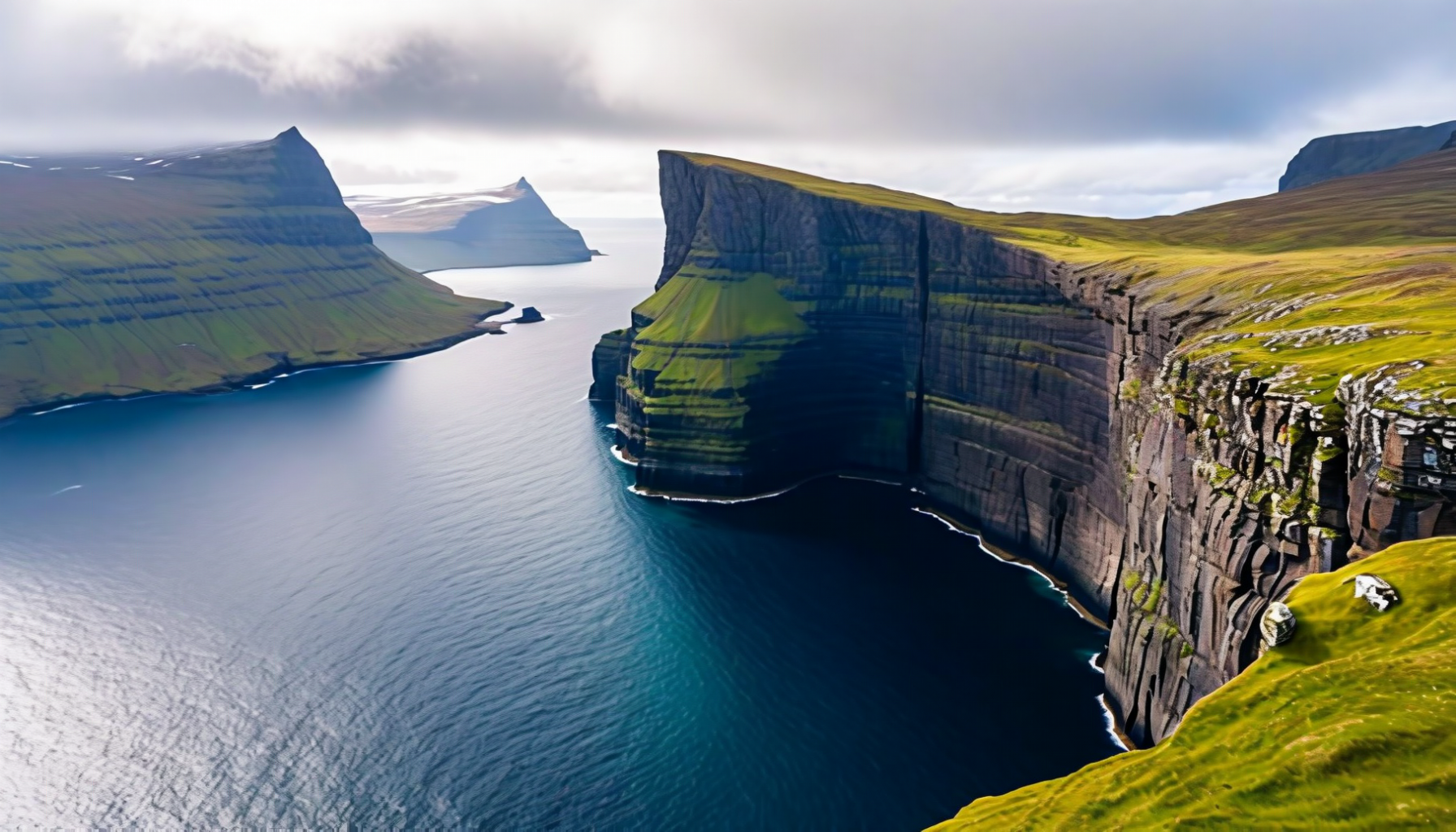
🗺️ Geography & the 18 Islands
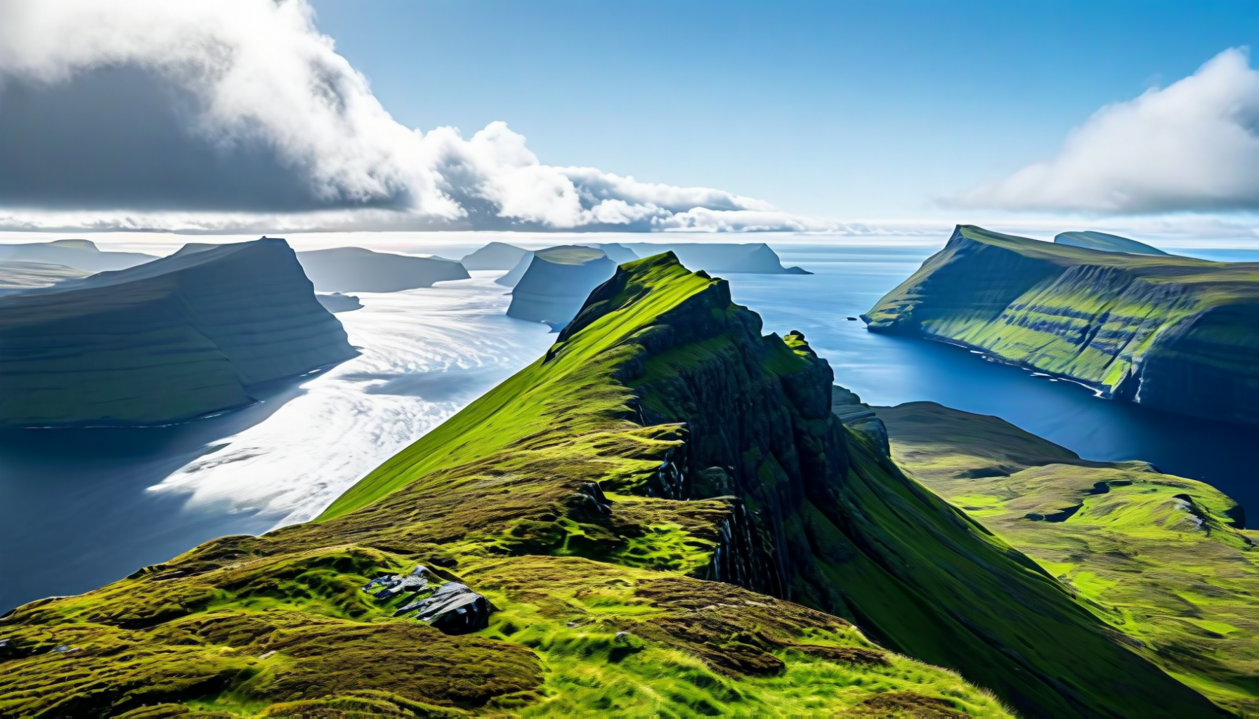
The archipelago consists of 18 main islands (17 inhabited) and hundreds of islets, spread across 1,399 km² in the North Atlantic at 62° N — roughly the same latitude as Anchorage or southern Greenland, yet warmed by the Gulf Stream into a cool, wet, remarkably green place. The islands are volcanic in origin, built of basalt laid down 55 million years ago when the North Atlantic was splitting open, and the horizontal lava layers are responsible for the characteristic stepped cliffs and flat-topped mountains.
The largest island is Streymoy, home to the capital Tórshavn. To its east, across the narrow Sundini strait, lies Eysturoy with the country's highest peak, Slættaratindur (882 m). The northern islands — Kalsoy, Kunoy, Viðoy, Borðoy and Svínoy — are long and narrow, cut by deep fjords. Vágar in the west hosts the airport and the famous Lake Sørvágsvatn. Mykines is the westernmost, a puffin sanctuary reached only in summer. Suðuroy, the southernmost, is the least visited. No point in the country is more than five kilometres from the sea.
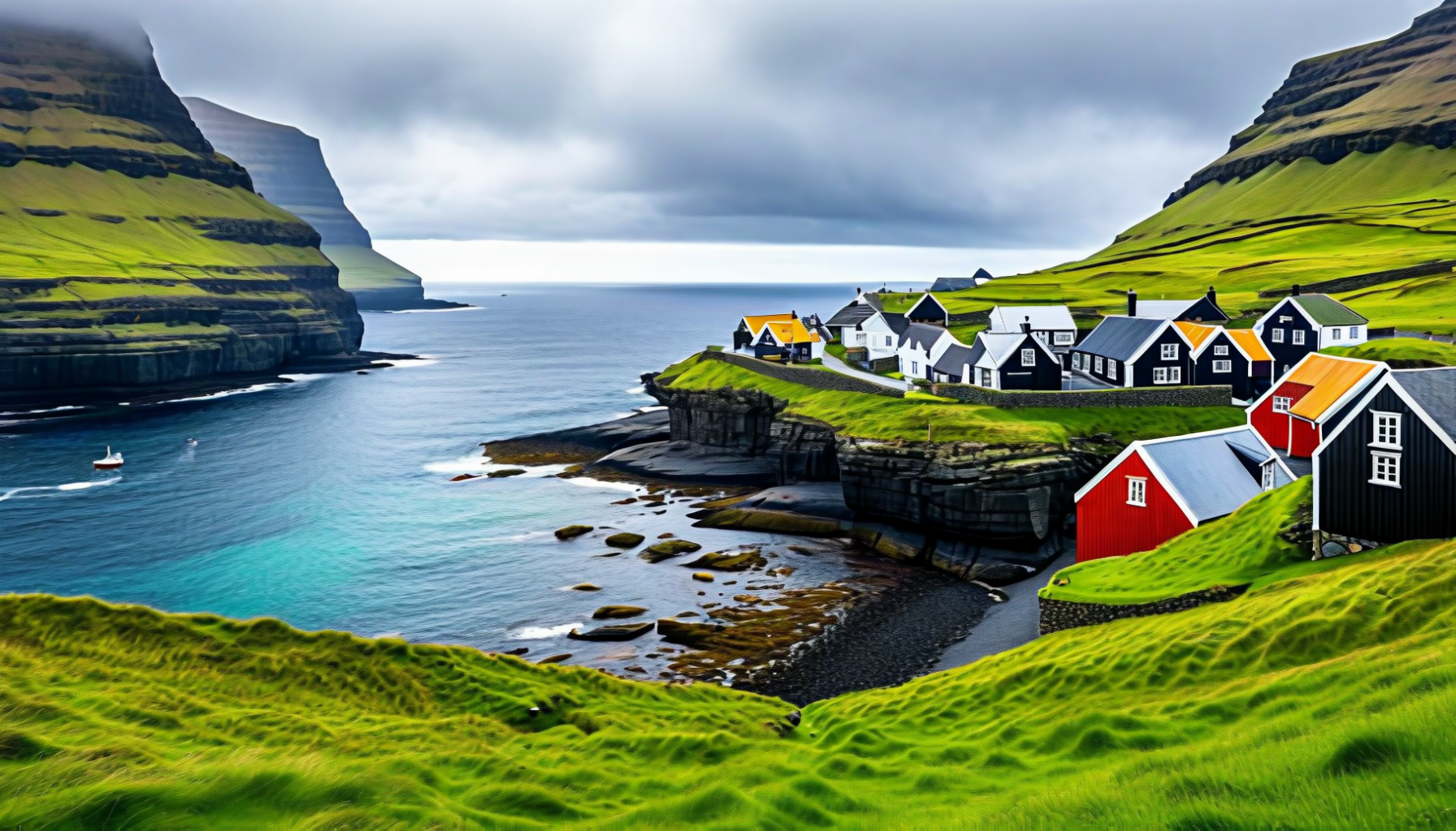
Saksun — turf-roofed chapel above a tidal lagoon (Streymoy)
03b
🗺️ Map
04
📜 History
Irish hermits — the papar — may have reached the islands in the 7th or 8th century, drawn by solitude and the sheep they left behind. The Norse arrived around 825 CE, followed by a permanent settlement traditionally associated with Grímur Kamban. By the 10th century the islands had their own parliament, the Løgting, meeting on the rocky Tinganes peninsula in Tórshavn — one of the oldest continuously functioning parliaments in the world.
Norway claimed the islands around 1035, and when the Kalmar Union brought Norway under Danish rule in 1380, the Faroes followed. They remained a quiet, impoverished Danish outpost for centuries, governed through a royal trade monopoly that wasn't fully dismantled until 1856. During the Second World War, the British occupied the Faroes after Denmark fell to Germany in 1940, and the period of de facto independence — with the Faroese flag flying officially for the first time — accelerated the drive for self-rule. Home rule came in 1948, and successive transfers of competence have left Denmark responsible for only defence, foreign affairs and the monetary system.
05
👥 People & Culture
The Faroese are genetically mostly descended from Norwegian Vikings on the male side and from Celtic (Irish and Scottish) women on the female side — a pattern of settlement also seen in Iceland. The population today is small, close-knit and remarkably young for Europe: a high birth rate and returning diaspora have kept the islands growing, and nearly everyone still speaks Faroese at home.
Culturally, the Faroes preserve the oldest living European dance tradition: the føroyskur dansur, the Faroese chain dance, where dancers hold hands in a ring and stamp the rhythm to ballads sung without instruments, some of them over 500 verses long. Knitted lopi sweaters, wool from native sheep, and a deeply rooted Christian (Lutheran) calendar shape daily life, and the islands have quietly become a Nordic music powerhouse — from Eivør Pálsdóttir's ethereal vocals to Týr's Viking metal.
06
🏛️ Tórshavn — The Tiniest Capital in Europe
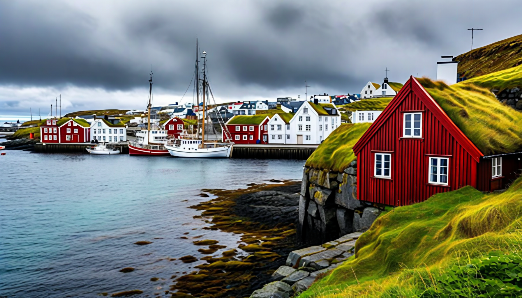
Tórshavn (Thor's Harbour) is one of the smallest and oldest capitals in Europe, founded on the Tinganes peninsula where the Viking parliament met from the 9th century onward. Today the old town is a cluster of red-painted, turf-roofed wooden houses squeezed along narrow cobbled lanes, with the current Faroese government still working from the same low timber buildings that have served for 400 years.
The harbour is busy and intimate — fishing boats, ferries to the outer islands and the occasional cruise ship all share the same basin. Nólsoy sits across the sound like a natural breakwater, and from Skansin, the 16th-century fort built to keep pirates at bay, you can watch the weather tumble in from the open Atlantic. Don't miss the modernist Nordic House, the quirky Listasavn Føroya art museum, and Áarstova or Barbara for New Nordic dining.
Tórshavn — red-painted parliament houses on the Tinganes peninsula
07
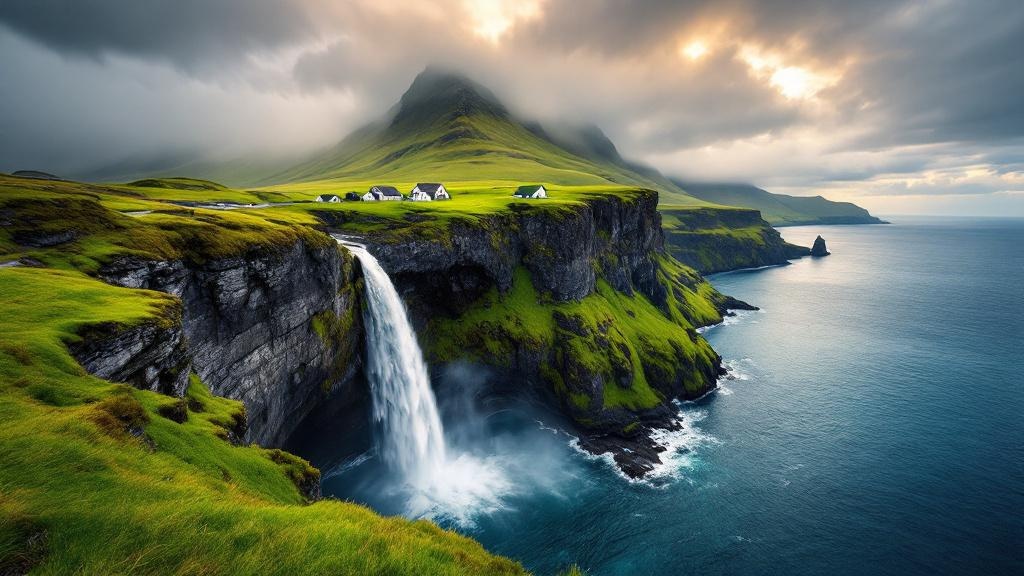
💦 Gásadalur & Múlafossur Waterfall
Until a road tunnel was blasted through the mountain in 2004, the tiny village of Gásadalur on the western tip of Vágar was accessible only by helicopter, boat or a steep footpath over the Postman's Trail. The reward for reaching it is the photograph every Faroe Islands brochure now shows: Múlafossur, a slender ribbon of water that drops straight off a 30-metre cliff into the North Atlantic, with the jagged silhouette of Mykines floating on the horizon beyond.
Arrive early in the morning or stay until the evening light turns gold on the cliffs. The classic viewpoint is a short walk from the village car park along a grassy path. The old postal route back to Bøur is a memorable 2–3 hour hike if the weather cooperates.
08
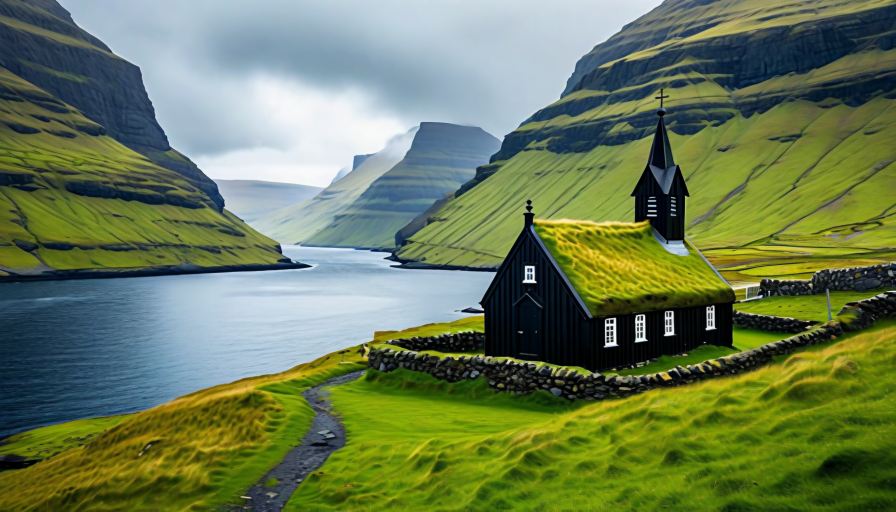
🏡 Saksun — Turf Roofs on a Tidal Lagoon
Saksun is what people picture when they imagine the Faroes: a handful of turf-roofed black houses, a tiny chapel with a grass roof, and a natural lagoon that fills and empties with the tide, ringed by 600-metre cliffs at the mouth of a fjord that the sea half-closed with a sandbar. Barely ten people still live here year-round, and the drive in from Streymoy's main road is one of the prettiest in the country.
You can walk down to the beach at low tide for a close look at the lagoon's mouth (check tide tables carefully — the water returns fast), and the trail over the ridge to Tjørnuvík on the other coast is one of the best day hikes in the country.
09
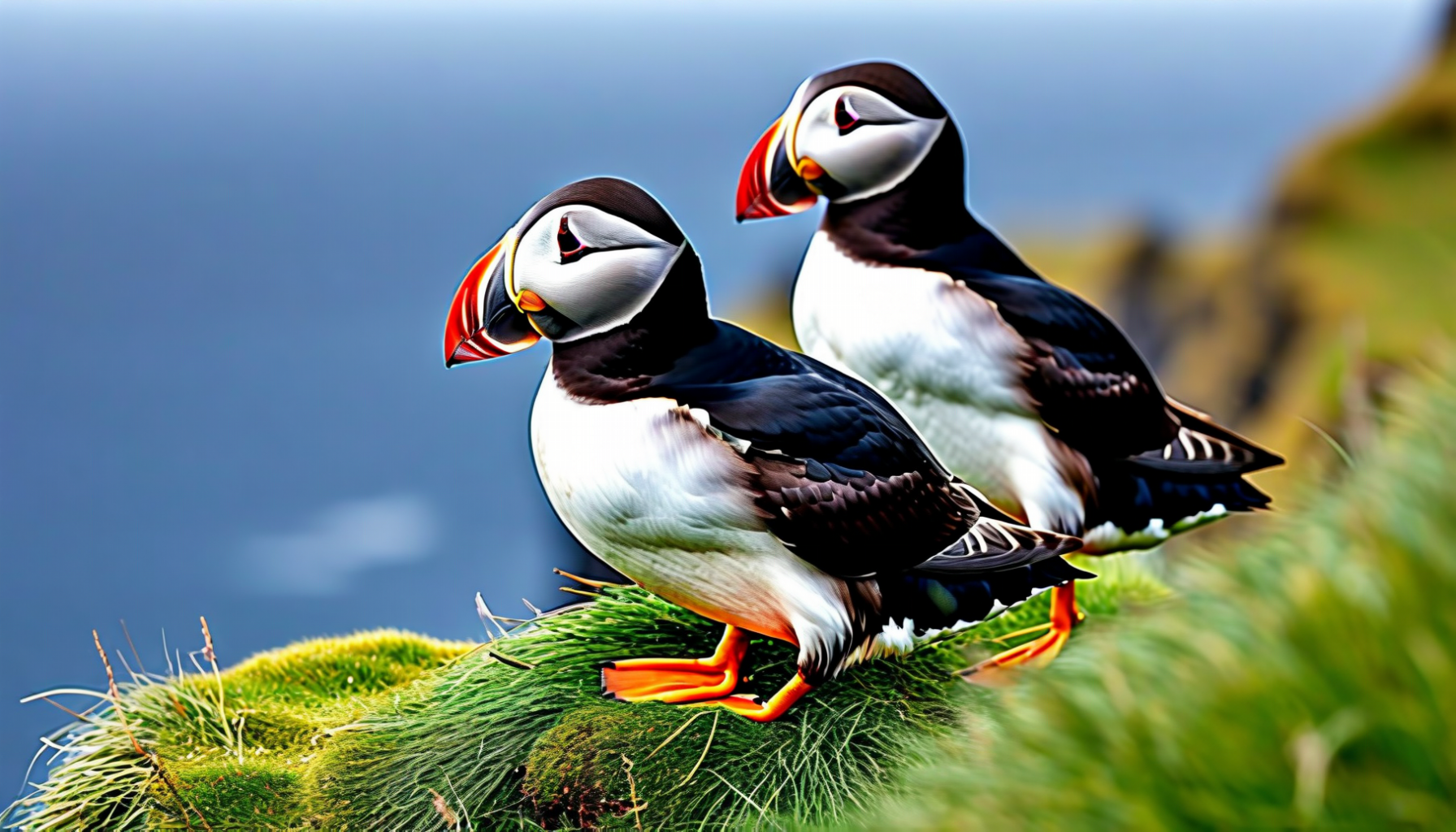
🐧 Mykines — Puffin Island
Mykines is the westernmost inhabited island, reached by a small ferry or a 10-minute helicopter ride from Vágar, and only in the summer season (May–August). Landing is weather-dependent; half the adventure is whether the boat can even dock at the rocky jetty. The reward, once you climb the steep path above the village, is one of the most concentrated puffin colonies in the North Atlantic — thousands of the small, clown-beaked seabirds nesting in burrows along the cliff tops.
A guided trail leads across the grassy headland to the lighthouse on Mykineshólmur, crossing a narrow footbridge slung above the churning sea. Bring windproof layers, sturdy boots, and expect to share the trail with sheep, gannets and Arctic terns. Access to the puffin cliffs is now regulated with a fee and a daily visitor cap to protect the birds.
10
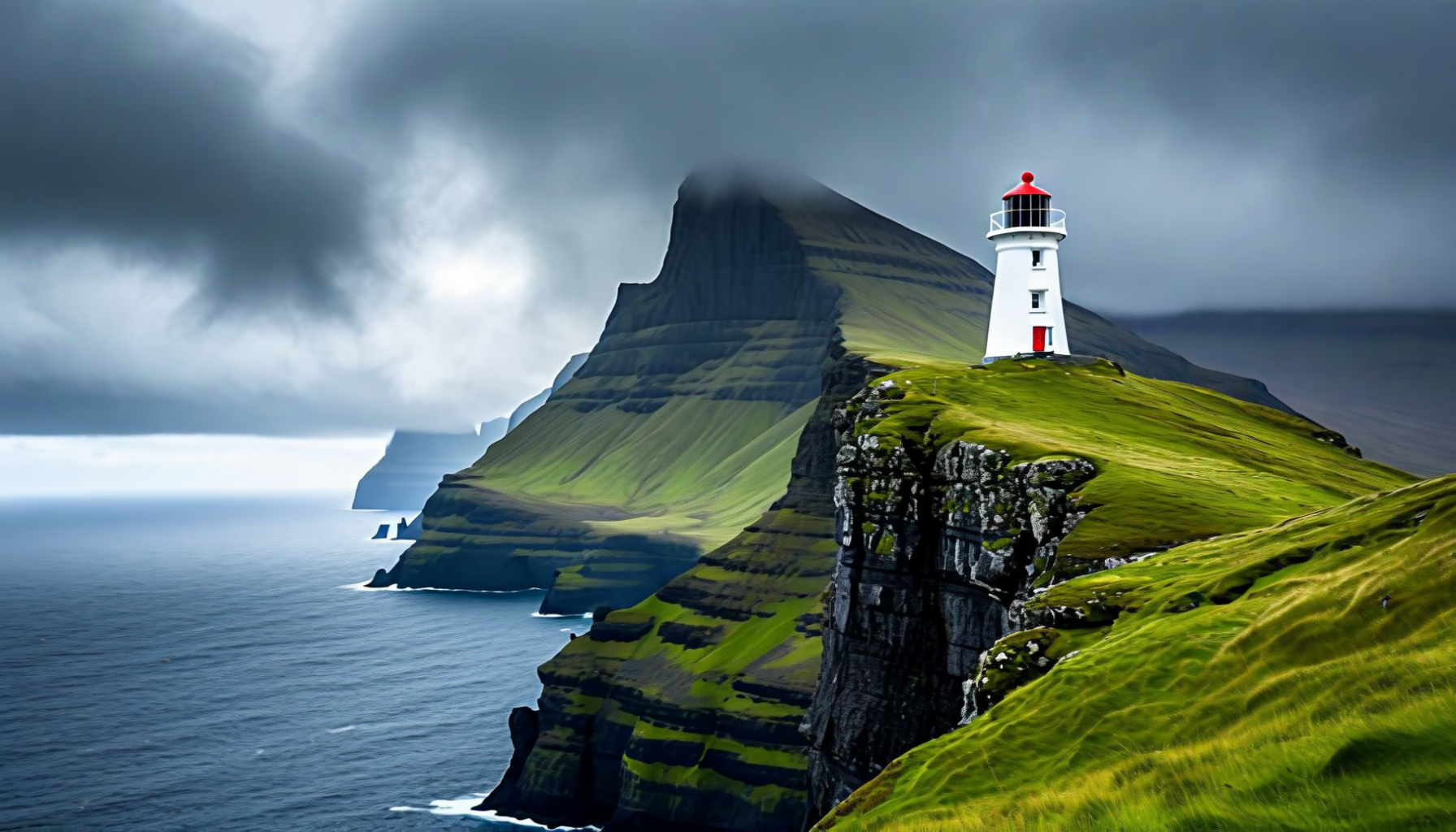
🔦 Kalsoy & the Kallur Lighthouse
Kalsoy is a long, narrow island northeast of Streymoy — nicknamed "the flute" for its shape and the tunnels that pierce it. Take the small car ferry from Klaksvík, drive the single road north through four one-lane tunnels, and park at the end of the road in Trøllanes. From there a 2-hour round-trip walk over green hills brings you to the Kallur lighthouse, perched on a knife-edge ridge with 300-metre cliffs falling into the Atlantic on three sides.
Kalsoy also hosts the bronze statue of Kópakonan, the Seal Woman of Mikladalur — a sorrowful figure on the rocks that references one of the islands' most famous folk tales. James Bond fans will recognise the island from the final scene of No Time to Die (2021).
11
🍜 Cuisine
Faroese food is shaped by what the sea and the sheep provide — and by the islands' long tradition of preserving it through the wind. The most distinctive technique is ræsting, a slow air-fermentation of lamb, fish and whale meat in the salt-laden Atlantic breeze, producing flavours that are unlike anything else in European cooking. The results range from the pungent ræst kjøt to the intensely savoury skerpikjøt, both eaten with pride at Christmas and on national holidays.
On the other end of the spectrum, Tórshavn now has two of the world's most celebrated New Nordic restaurants — Koks (two Michelin stars) and Ræst — both built around foraging, fermentation and hyper-local seafood. For more everyday dining, expect plaice fresh from the morning's boats, lamb soup (seyðasúpan), rhubarb and crowberry desserts, and the ubiquitous kleyna doughnuts for afternoon coffee.
🍖 Ræst Kjøt — Wind-Fermented Lamb
Ingredients: leg or shoulder of mature Faroese lamb, coarse sea salt.
Method: Lightly salt the lamb and hang it in a hjallur — a slatted wooden drying shed open to the Atlantic wind — for 3 to 8 weeks in autumn. The cool, humid salt air ferments rather than dries the meat, producing a deeply savoury, umami-rich texture that is closer to aged cheese than dried beef. Boil gently and serve with boiled potatoes, root vegetables and a knob of butter. The flavour is powerful — part of the Faroese gastronomic identity and a hallmark of Koks, the islands' two-Michelin-star restaurant.
🐟 Skerpikjøt & Garnatálg
Skerpikjøt is lamb fermented even longer (5–9 months) until it is fully wind-dried and shaved into paper-thin slices, eaten raw with rye bread and butter. Garnatálg is rendered sheep fat seasoned with herbs — a traditional accompaniment. Fish dishes dominate the rest of the menu: boiled cod with liver and roe, smoked salmon, and grilled Atlantic halibut.
12
🍺 Beer, Akvavit & Faroese Drinks
The Faroes are not a wine-producing country — the latitude and the wind see to that — but they have their own proud brewing and distilling traditions. Föroya Bjór, founded in Klaksvík in 1888, is the national brewery, and its pale lager, Rinkusteinur bitter and annual Christmas brew (Jólabrúgv) are staples of every festive table. The micro-scale Okkara brewery adds a more craft-oriented range.
Spirits arrive courtesy of akvavit-style bitters, including the Faroese national liqueur Eldvatn — a schnapps infused with angelica and caraway. A peculiarity of Faroese law: alcohol stronger than light beer can only be bought in state-run Rúsdrekkasøla shops, which keep short opening hours, or in licensed restaurants. Plan ahead if you want a bottle for your cottage evening.
12b
🍹 Cocktails & Mixed Drinks
Cocktail culture in the Faroes is young but growing, led by Tórshavn bars like Sirkus and Hvonn. Expect cocktails built around local botanicals — angelica, crowberry, rhubarb, sea buckthorn — and Nordic spirits. Two drinks worth trying:
🍸 Crowberry & Aquavit Sour
Ingredients: 50 ml Nordic aquavit, 20 ml lemon juice, 15 ml crowberry syrup, 15 ml egg white, dash of Angostura bitters.
Method: Dry-shake, then shake with ice, strain into a coupe. Garnish with a few fresh crowberries and a sprig of angelica.
🌿 Rhubarb & Angelica Highball
Ingredients: 40 ml Eldvatn (or caraway schnapps), 20 ml rhubarb cordial, soda water, ice.
Method: Build in a highball over ice, top with soda, stir once. Garnish with a thin ribbon of cucumber and a young angelica leaf.
13
🌡️ Climate & Best Time to Visit
The Faroes have a subpolar oceanic climate — cool, windy and changeable, with summer highs around 13 °C and winters hovering just above freezing thanks to the Gulf Stream. It can rain on 300 days a year, but the weather swings so fast that sunshine is rarely far away. Locals say: "If you don't like the weather, wait ten minutes."
The best window is late May to early September, when daylight stretches to 19 hours at the solstice, ferries run to Mykines, and hiking trails are mostly snow-free. September brings autumnal colour and the Northern Lights reappear over dark skies. Winter is dramatic and photographic but many attractions and ferries shut down; pack for wind more than cold.
14
✈️ Getting There
Vágar Airport (FAE) is the only airport in the Faroes. The national carrier Atlantic Airways flies year-round from Copenhagen, Billund, Reykjavík, Edinburgh and (seasonally) Bergen, Paris, Barcelona, Mallorca and New York. SAS also operates from Copenhagen in summer. The airport sits on Vágar, an hour's drive from Tórshavn through the sub-sea Vágatunnilin.
For a more adventurous approach, the Smyril Line car ferry Norröna sails weekly year-round between Hirtshals (Denmark), Tórshavn and Seyðisfjörður (Iceland) — about 36 hours from Denmark, with a cabin or a couchette. Bringing your own vehicle is the only way to guarantee one, since rental cars on the islands are limited.
15
📋 Practical Information
The Faroes are part of the Kingdom of Denmark but not part of the European Union or the Schengen Area. Most Western visitors (EU, UK, US, Canada, Australia, NZ and many others) can enter visa-free for up to 90 days. A valid passport is required — a Danish or Schengen visa does not automatically cover the Faroes and must have a specific endorsement.
The local currency is the Faroese króna (FOK), which is pegged 1:1 to the Danish krone (DKK) and the two circulate interchangeably. Card payments are accepted almost everywhere, including remote villages. Driving is on the right; the road network is excellent; sub-sea tunnels (Vágatunnilin, Norðoyatunnilin, Eysturoyartunnilin with its famous roundabout) charge tolls, usually paid automatically via the rental car. Health care is modern and good; travel insurance with repatriation is still recommended.
16
💰 Cost of Living
Prices are close to Danish or Norwegian levels — not cheap. Expect to budget around €100–150 per person per day for mid-range travel, including car rental and accommodation. A sit-down dinner for two with drinks runs €60–120, a Föroya Bjór beer in a bar €8–10, a coffee and pastry €6, a tank of fuel roughly €80. Koks tasting menus and helicopter sightseeing flights are splurges but memorable ones.
17
🏨 Accommodation
Accommodation ranges from Tórshavn's elegant Hotel Føroyar (with its turf roof blending into the hillside) and the centrally-located Hotel Hafnia, to dozens of guesthouses, Airbnbs and traditional heimagisting (home stays). For an authentic experience, book a turf-roofed cottage in Gjógv, Funningur or Mikladalur. Booking early is essential in July and August — the country is small and rooms are limited.
18
🎭 Festivals & Events
Ólavsøka (28–29 July) is the national day, marking the opening of the Løgting and the feast of St Olaf. Tórshavn fills with rowing races, horse parades, chain dancing, and wool-sweater-wearing Faroese from every island. G! Festival in Syðrugøta (mid-July) is the country's biggest music festival, held literally on the beach. Summarfestivalur in Klaksvík (early August) is the other major one. For culture lovers, Summartónar is a classical and contemporary music festival running June–August across the islands.
19
🏛️ UNESCO & World Heritage
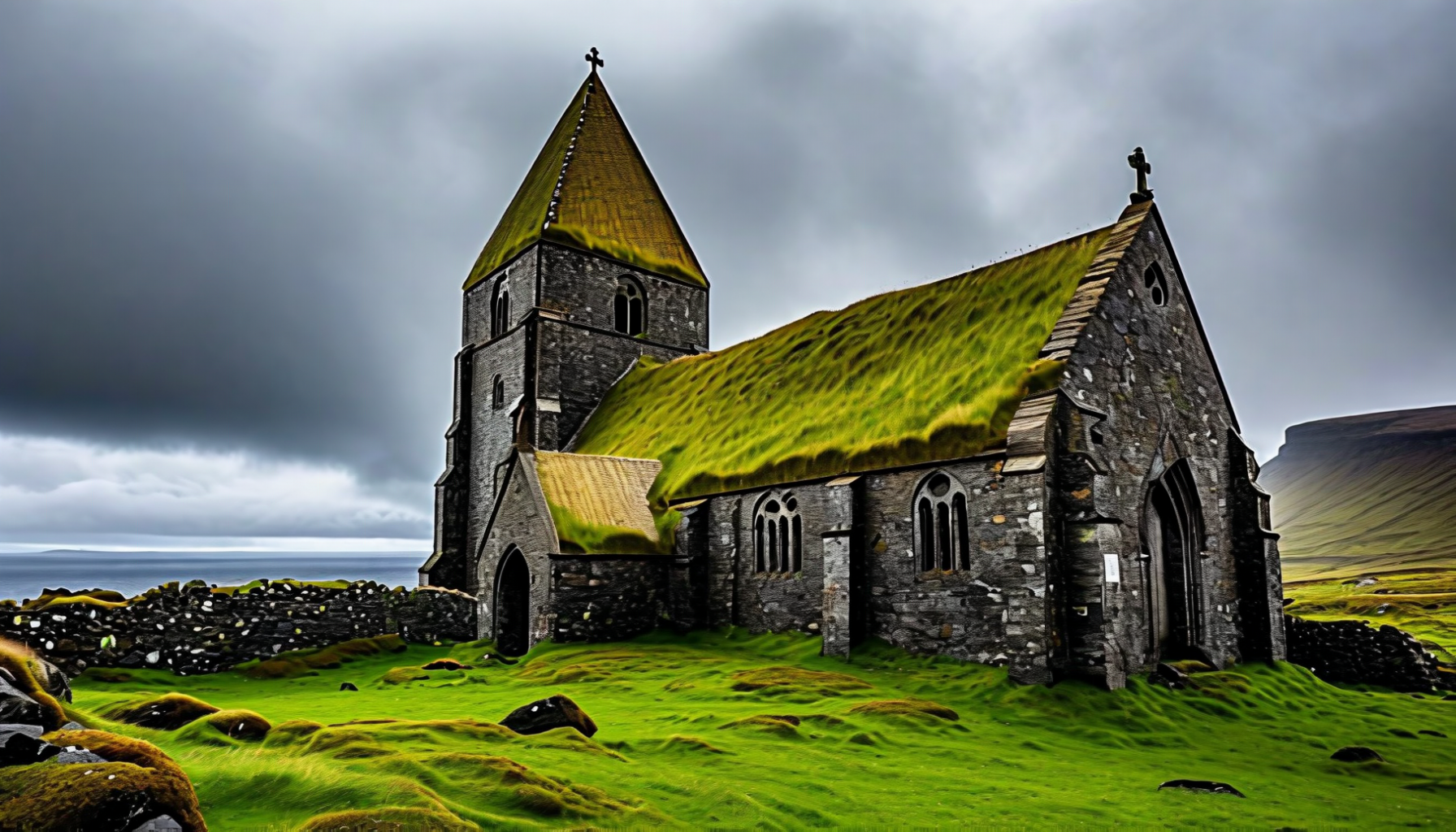
The Faroe Islands currently have no inscribed UNESCO World Heritage Sites, but two outstanding sites are on Denmark's tentative list on behalf of the islands: Kirkjubøur — a medieval bishopric with the ruined Magnus Cathedral (begun around 1300), St Olav's Church (c. 1100) and the Kirkjubøargarður farmhouse, one of the oldest continuously inhabited wooden houses in the world; and the traditional Faroese grind (pilot whale drive) cultural landscape. Kirkjubøur is an easy half-day trip from Tórshavn and should not be missed.
20
💎 Hidden Gems
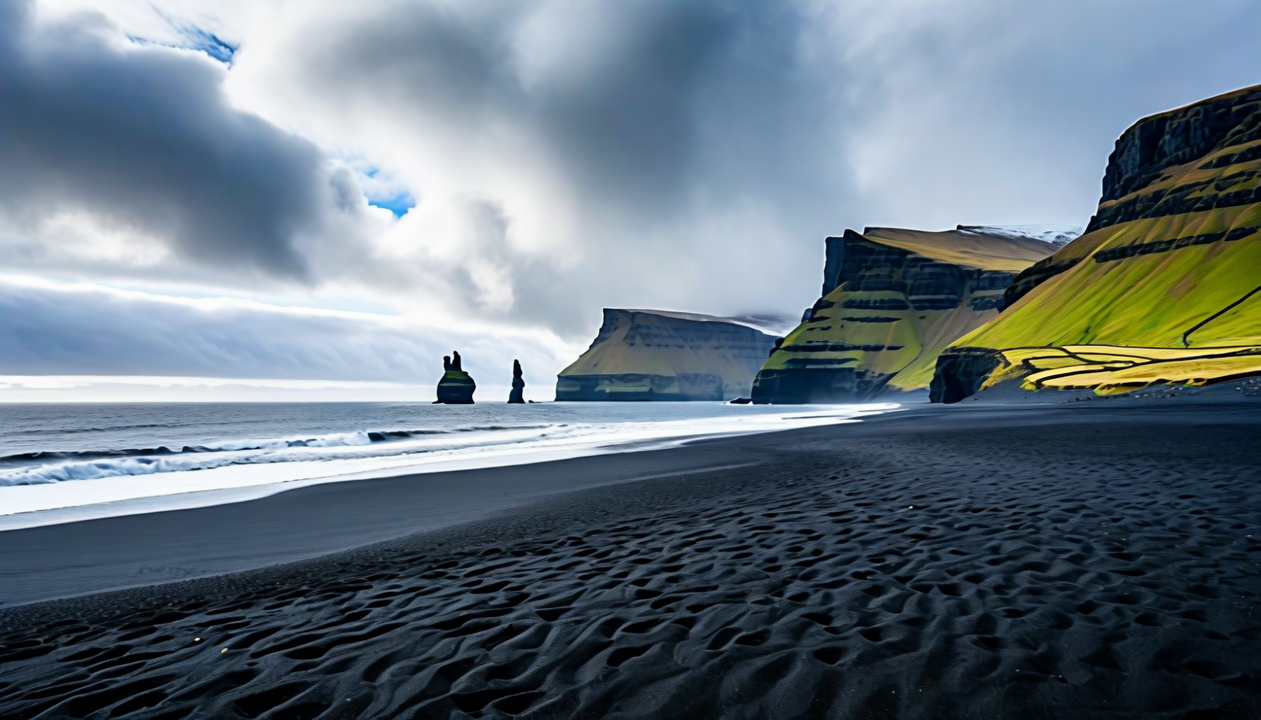
Beyond the Instagram classics, the islands reward the curious. Try Tjørnuvík, a black-sand bay with a view of the Risin og Kellingin sea stacks; Gjógv, a village built around a perfect natural rock harbour on the north coast of Eysturoy; Viðareiði, mainland Europe's northernmost village, with Cape Enniberg (754 m) — one of the highest sea cliffs in the world — rising behind it; and Nólsoy, the little island opposite Tórshavn, famed for its storm petrel colony and easy ferry access.
Hardcore hikers should walk to the abandoned village of Víkar on Vágar or climb Slættaratindur (882 m), the country's highest peak, on a rare clear day — the summit view takes in most of the archipelago.
21
🎒 Packing Tips
Waterproof shell jacket and trousers, not just a windbreaker. Warm mid-layers (fleece or wool), even in July. Sturdy, waterproof hiking boots. Gloves and a beanie — the wind chill is real. Sunglasses (for the rare sun and the snow glare on nearby ridges). A good camera or phone, a dry bag, and a roll of high-denomination patience for when the fog closes in.
22
🌐 Useful Resources
Official tourism: visitfaroeislands.com. Ferry schedules: ssl.fo (Strandfaraskip Landsins, domestic ferries and buses). Atlantic Airways: atlantic.fo. Smyril Line car ferry: smyrilline.com. Weather forecast (hour-by-hour, very reliable): yr.no. Mykines landing information: visitmykines.fo.
23
📚 Recommended Reading
The Lost Musicians and The Black Cauldron by William Heinesen — the Faroes' great 20th-century novelist, writing in Danish but deeply Faroese in spirit. Barbara by Jørgen-Frantz Jacobsen — a classic Faroese novel set in the 18th century. The Old Man and His Sons by Heðin Brú — a quiet, much-loved portrait of a Faroese fisherman caught between tradition and the modern world. For travellers: Lonely Planet Iceland, Greenland & Faroe Islands, and the Bradt Faroe Islands guide by James Proctor.
24
🎬 Videos About the Faroe Islands
Search YouTube for Visit Faroe Islands' official channel (including the brilliant "Remote Tourism" campaign filmed during the pandemic), Faroe Islands Translate (the islands' volunteer real-time translation service), Eivør live concerts, and the drone footage collections of Ivan Slunjski and Kasper Solberg. The opening sequence of the James Bond film No Time to Die is also filmed on Kalsoy.
25
🔬 Fascinating Facts
Sheep outnumber humans roughly 3:2. The islands have their own internet TLD (.fo) and national football team that has famously beaten Austria, Greece and Lithuania in competitive matches. The Faroese language is one of the smallest living North Germanic languages but has produced more books per capita than almost any other country on Earth. The optical illusion at Sørvágsvatn — the lake that looks as if it hangs hundreds of metres above the ocean — is the result of perspective from a specific angle along the cliffs of Trælanípa. And the islands have no McDonald's, no Starbucks and only two sets of traffic lights.
26
⭐ Notable People
Eivør Pálsdóttir — internationally renowned singer and composer whose ethereal voice has scored Game of Thrones: House of the Dragon and numerous Nordic films. Teitur Lassen — singer-songwriter who has played with Rufus Wainwright. William Heinesen (1900–1991) — poet and novelist, widely considered the Faroes' greatest writer. Heðin Brú (1901–1987) — novelist. Tróndur Patursson — sculptor, glass artist and explorer. Poul Anker Skaale — veteran politician and former PM. The band Týr have become ambassadors for Faroese Viking-themed metal.
27
⚽ Sports
Football is the national obsession — the Faroe Islands national team famously beat Austria 1–0 in their first competitive match in 1990, a result still celebrated today. Domestic football (Betri deildin) is surprisingly serious for a country of 54,000, with clubs like Víkingur Gøta and B36 Tórshavn qualifying for European competition. Rowing — specifically kappróður, the Faroese rowing regatta in traditional wooden boats — is the great summer sport, and the finals at Ólavsøka in Tórshavn draw the entire nation. Handball and swimming are also strong.
28
📰 Media & Press Freedom
Press freedom in the Faroes is strong, inheriting Denmark's robust tradition. The main newspapers are Sosialurin and Dimmalætting, and Kringvarp Føroya (KVF) is the national public broadcaster, operating radio and television services in Faroese. A small population means journalists know their subjects personally, which cuts both ways — coverage is close and local, but also socially cautious.
29
📸 Photo Gallery
A selection of Faroe Islands landscapes — click any image to open it full-size. All photos should feel unhurried: the archipelago rewards the traveller who waits for the weather to turn.
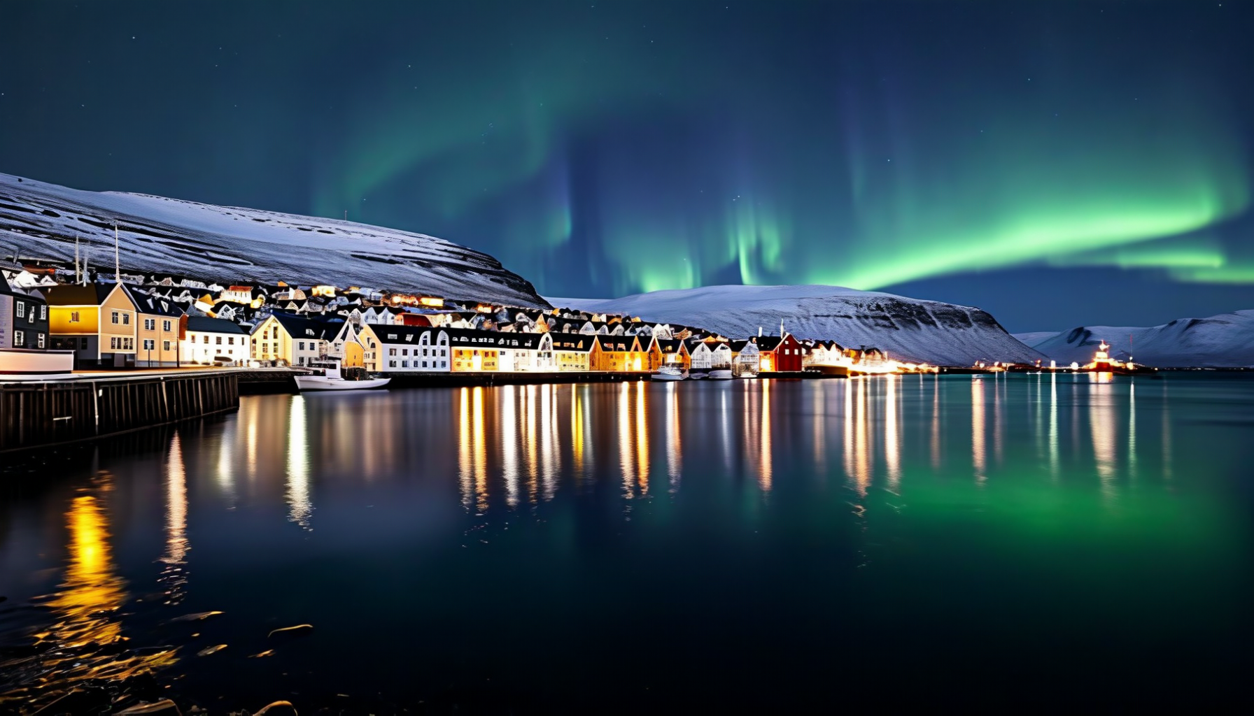
Tórshavn at night
Sørvágsvatn — the floating lake
Kallur Lighthouse, Kalsoy
Puffins on Mykines
Tjørnuvík beach
Gjógv village harbour
Slættaratindur summit view
Kirkjubøur medieval ruins
30
✍️ Author's Note
I arrived on the Faroes on a grey September afternoon, the kind where the clouds hang so low over Vágar airport that the wings of the plane seem to brush the sheep on the runway grass. Within an hour the clouds opened over Múlafossur, the sea turned silver, and a single beam of sun picked out the white church at Bøur like a spotlight. I understood then what everyone had tried to explain: the Faroes are not a place you visit on a schedule, they are a place you surrender to. You drive, you park, you wait — and the islands deliver a new postcard every twenty minutes, sometimes angry, sometimes impossibly gentle.
What stayed with me, more than the photographs, was the quiet. The wind on the Kallur ridge with the Atlantic 300 metres below, the soft rustle of sheep moving over Saksun's turf roofs, the Faroese chain dance spilling out of a community hall in Gøta where the singers had been repeating the same ballad — Ormurin langi — since before my own country existed. I came expecting drama and found tenderness; a small, proud people who have chosen to live between two larger neighbours and who, somehow, have built a place that feels more itself than almost anywhere else in Europe.
Go in summer for the puffins and the midnight light, go in winter for the auroras and the silence, but go. You will leave with wet boots, a windburn, a sheep-wool sweater you didn't plan to buy, and the strangest certainty that you have been somewhere real.