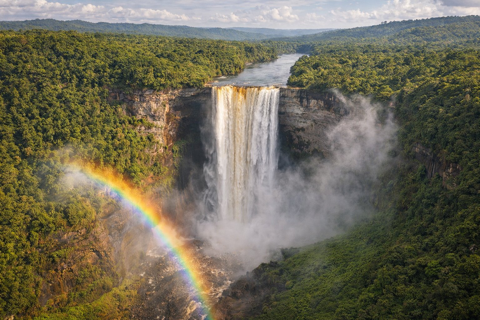
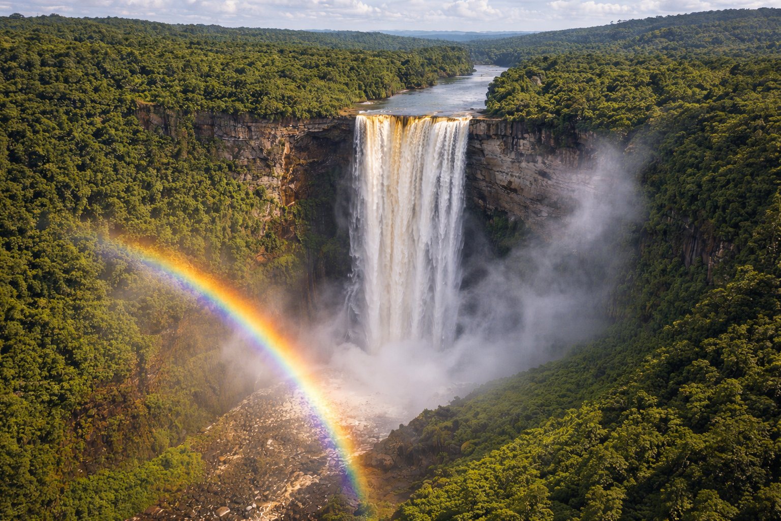
There is a moment, flying over the Guyanese interior in a small Cessna, when the vast green carpet of Amazon rainforest gives way to a sudden, thunderous void—Kaieteur Falls, five times the height of Niagara, plunging 226 meters into a mist-shrouded gorge. No guardrails, no crowds, no gift shops. Just raw, primal power witnessed by perhaps a dozen travelers on any given day. This is Guyana—South America's best-kept secret, a land where jaguars prowl pristine rainforests, giant river otters hunt in blackwater creeks, and indigenous communities maintain traditions stretching back millennia.
The "Land of Many Waters" lives up to its name. The Essequibo, Demerara, and Berbice rivers carve through 83% forest cover, creating one of the world's last great wilderness frontiers. English-speaking and Caribbean in culture yet South American in geography, Guyana defies easy categorization. Georgetown's wooden colonial architecture, the savanna grasslands of the Rupununi, and the ancient tepui mountains shared with Venezuela and Brazil each tell different chapters of this improbable nation's story.
Recent offshore oil discoveries have transformed Guyana into one of the world's fastest-growing economies, but the interior remains magnificently undeveloped. For travelers seeking authentic adventure—not the curated kind—Guyana offers birding that rivals anywhere on Earth, indigenous lodges deep in the rainforest, and the chance to experience a South America that existed before the tour buses arrived. This is not a destination for resort seekers or those requiring predictable comforts. It is for those who understand that the best journeys require effort, and that the reward is proportional to the challenge.
🌿 Ecotourism Pioneer
Conservation Success: Guyana has maintained over 85% forest cover and pioneered innovative conservation-for-payment programs. The country received international recognition for keeping deforestation rates among the lowest in the world.
Best Time to Visit: The dry seasons (February-April and September-November) offer easier travel conditions. The interior becomes challenging during heavy rains when dirt airstrips may close.
💚 2024-2025 Oil Boom: Offshore oil production has made Guyana the world's fastest-growing economy. While this brings infrastructure improvements, the interior tourism experience remains refreshingly unchanged. New direct flights from Miami and Toronto have improved access significantly.
Kaieteur Falls from Above
The world's mightiest single-drop waterfall plunges 226 meters into pristine rainforest
02
🏷️ Name & Identity
The name "Guyana" derives from indigenous words meaning "Land of Many Waters"—an apt description for a country where the Essequibo, Demerara, Berbice, and countless smaller rivers carve through dense rainforest to reach the Atlantic. The Arawak and Carib peoples who first named these lands understood water as the essential element defining this place, and their insight remains valid centuries later.
Guyana's distinctive flag—the "Golden Arrowhead"—tells the nation's story in bold colors. Green represents the forests covering 85% of the land, white symbolizes the rivers and water potential, gold stands for mineral wealth, black reflects the endurance of the people, and red represents their zeal and sacrifice. The arrow shape points toward the future while honoring the country's indigenous heritage.
Uniquely positioned as the only English-speaking country in South America, Guyana straddles multiple identities. Culturally Caribbean yet geographically South American, its population of Indo-Guyanese (descendants of Indian indentured laborers), Afro-Guyanese, Indigenous peoples, Chinese, Portuguese, and mixed-heritage citizens creates a remarkably diverse society. Cricket, Caribbean music, Hindu temples, and Christian churches all find their place here.
This cultural complexity shapes the Guyanese character—pragmatic yet warm, proud of their independence yet connected to Caribbean and Commonwealth traditions. The phrase "one people, one nation, one destiny" captures the aspiration for unity amid diversity that has guided this young nation since independence from Britain in 1966.
03
🗺️ Geography & Regions
Guyana occupies 214,969 square kilometers on South America's northeastern shoulder, bordered by Venezuela to the west, Brazil to the south, Suriname to the east, and the Atlantic Ocean to the north. The country divides naturally into four distinct zones: the narrow coastal plain where 90% of the population lives, the forested highlands of the interior, the Rupununi savannas in the southwest, and the Pakaraima Mountains along the Venezuelan and Brazilian borders.
The coastal plain, much of it below sea level and protected by Dutch-built seawalls, contains Georgetown and the sugar-growing regions that historically drove the economy. Move inland and the land rises through rolling hills to the vast Amazonian rainforest that covers most of the country's interior—one of the most pristine wilderness areas remaining on Earth.
The Rupununi Savanna in the southwest offers dramatic contrast: open grasslands stretching to distant horizons, dotted with termite mounds and crossed by gallery forests following river courses. This cattle country, home to Makushi and Wapishana indigenous communities, borders Brazil's northern frontier. The Pakaraima Mountains rise beyond, including sections of the famous tepui (table-top mountain) formations and Guyana's highest point, Mount Roraima (2,810m), shared with Venezuela and Brazil.
Three great rivers define the landscape: the Essequibo (the longest at 1,014 km), the Demerara (giving its name to a type of sugar), and the Berbice in the east. These waterways historically served as the primary transportation routes into the interior and remain crucial today for communities beyond the reach of roads. The country's ten administrative regions span from the crowded coast to wilderness areas where jaguars outnumber humans.
03b
🗺️ Map
04
📜 History
Indigenous peoples—Arawak, Carib, and Warao—inhabited this land for thousands of years before European contact. The Arawaks developed sophisticated agriculture along the rivers, while Carib warriors dominated the coastal regions. Their descendants, the "Amerindians" as they're locally known, maintain communities throughout the interior today, preserving languages, traditions, and ecological knowledge accumulated over millennia.
The Dutch established the first European settlements in the early 1600s, developing the Essequibo, Demerara, and Berbice colonies through brutal plantation agriculture. African enslaved people, forced to work the sugar plantations, built the seawalls and drainage systems that still protect the coastal plain. The 1763 Berbice Slave Rebellion, led by Cuffy (now a national hero), represented one of the largest slave uprisings in the Americas.
Britain took control in 1814, consolidating the Dutch colonies into British Guiana. After emancipation in 1838, plantation owners recruited indentured laborers from India, fundamentally reshaping the colony's demographics. Portuguese from Madeira and Chinese workers added further diversity. This colonial history created the ethnic mix—and tensions—that continue to shape Guyanese politics.
Independence came on May 26, 1966, followed by a turbulent post-colonial period. Forbes Burnham's authoritarian rule (1964-1985) included the nationalization of key industries and the tragic 1978 Jonestown massacre, when more than 900 members of an American cult died in the jungle interior. Democratic reforms in the 1990s brought stability, and the 2015 discovery of massive offshore oil reserves—with commercial production beginning in 2019—has transformed Guyana's economic prospects, making it one of the world's fastest-growing economies.
05
👥 People & Culture
Guyana's approximately 810,000 people represent one of the most diverse populations in the Americas. Indo-Guyanese (descendants of Indian indentured laborers) comprise about 40% of the population, Afro-Guyanese around 30%, mixed heritage about 20%, and Indigenous peoples (Amerindians) roughly 10%. Smaller Chinese, Portuguese, and European communities add further diversity. This ethnic mosaic, while sometimes a source of political tension, creates a remarkably rich cultural tapestry.
Despite being in South America, Guyanese culture is distinctly Caribbean. Cricket isn't just popular—it's a national obsession. Calypso, soca, chutney (Indian-influenced Caribbean music), and reggae fill the airwaves. The food reflects the cultural blend: curry and roti from the Indian tradition, cook-up rice from African heritage, pepper pot (an Amerindian stew often served at Christmas), and fresh seafood from the Atlantic coast.
Religious diversity matches ethnic variety. Hinduism and Christianity (Anglican, Catholic, and evangelical denominations) claim the largest followings, with significant Muslim communities and practitioners of indigenous spiritual traditions. Hindu festivals like Phagwah (Holi) and Diwali, Christian holidays, and Islamic celebrations all receive national recognition—Guyana may be the only country where both Diwali and Christmas are public holidays.
The warmth of Guyanese hospitality surprises many visitors. Despite economic challenges, sharing food and conversation with strangers comes naturally. "Liming"—the Caribbean art of hanging out and enjoying life—defines social culture. English serves as the official language, but most Guyanese speak Creolese (Guyanese Creole) in daily life, a vibrant language blending English with African, Indian, and indigenous influences.
🗣️ Guyanese Creole Phrases
Common Expressions:
Wha gwan? — What's happening?
Awright — Alright/Hello
Leh we go lime — Let's hang out
Big up — Respect/Greeting
Tek care — Take care/Goodbye
Useful Words:
Gyal/Bai — Girl/Boy
Fuh true — Really/For real
Meh nah know — I don't know
Proper ting — That's right
06
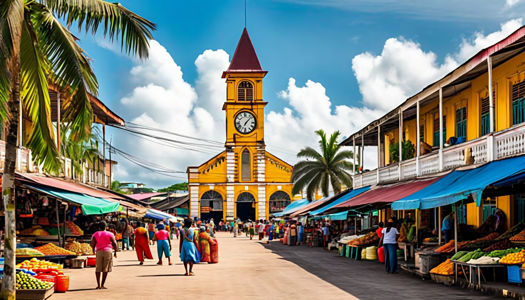
🏛️ Georgetown — The Garden City
Georgetown sprawls along the Atlantic coast at the mouth of the Demerara River, a city built below sea level and protected by the Dutch-era seawall that has held back the ocean for centuries. Home to roughly 240,000 people (a third of Guyana's population), the capital presents an intriguing blend of Caribbean vitality, colonial heritage, and tropical decay that rewards curious travelers willing to look beyond first impressions.
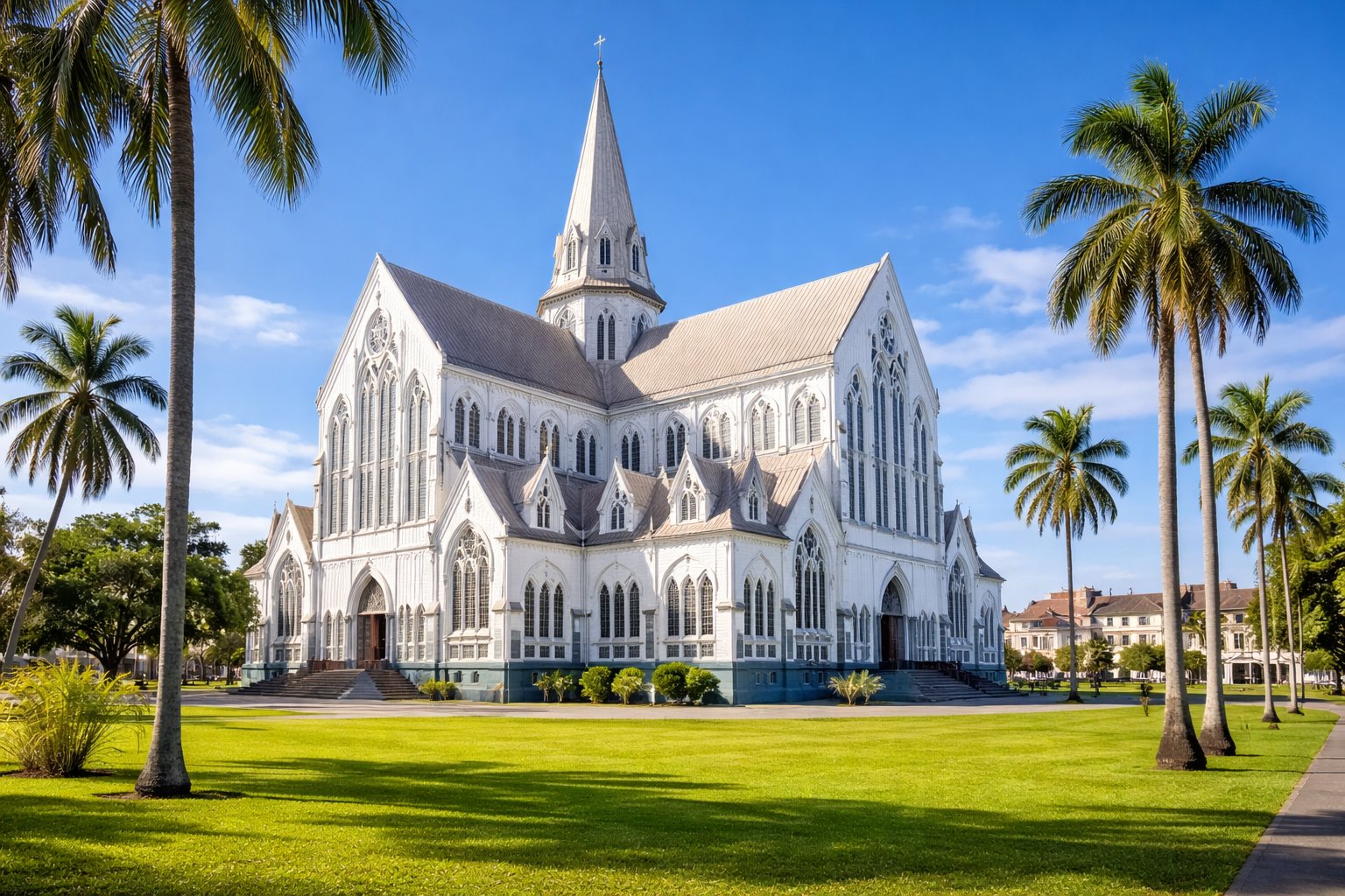
The city's greatest treasure is its wooden colonial architecture—some of the finest in the Caribbean. St. George's Cathedral, one of the world's tallest wooden buildings at 43 meters, rises in Gothic splendor above the urban landscape. City Hall, the Parliament Building, and countless private homes display the elaborate fretwork and elevated construction (protecting against floods) that define Guyanese architectural tradition. Many buildings desperately need restoration, but this faded grandeur creates an authentic atmosphere lacking in more polished destinations.
The Stabroek Market, with its distinctive cast-iron clock tower, serves as the city's commercial heart—a sprawling, chaotic marketplace where you can buy everything from fresh fish to fabric, gold jewelry to local produce. Bourda Market offers similar energy with more food focus. The Promenade Gardens and Botanical Gardens provide green respite, the latter containing a zoo and the graves of several national figures.
For visitors, Georgetown works best as a base for interior expeditions rather than a destination in itself. The waterfront seawall offers sunset views, and the city's restaurants serve excellent curry, Caribbean seafood, and multicultural cuisine reflecting Guyana's diverse population. The National Museum provides context for the country's history, while the lively nightlife scene showcases Caribbean culture at its most vibrant.
Georgetown's Colonial Heritage
The iconic St. George's Cathedral — one of the world's tallest wooden buildings rises above the Garden City
07
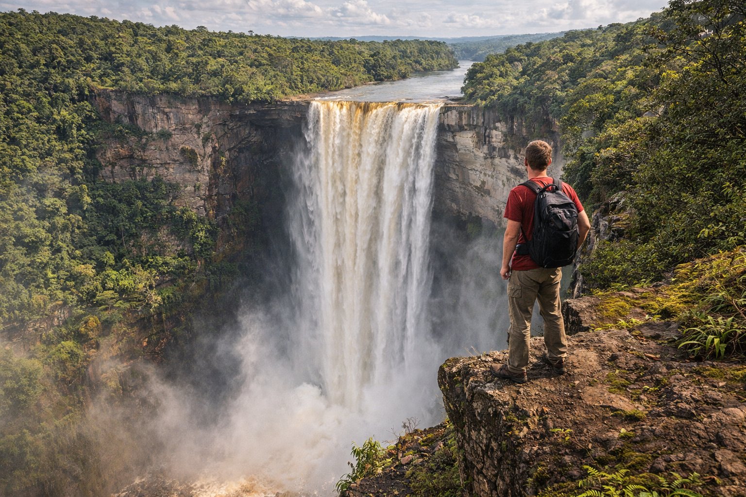
💧 Kaieteur Falls — World's Most Powerful Waterfall
Kaieteur Falls drops 226 meters in a single, thundering plunge—five times the height of Niagara and arguably the most powerful waterfall on Earth by volume of water at that height. Located deep in the Potaro-Siparuni region, accessible only by small aircraft or multi-day trek, Kaieteur represents the crown jewel of Guyanese ecotourism and one of South America's most spectacular natural wonders.
The experience of Kaieteur defies description. Small planes land on a grass airstrip above the falls, and visitors walk to viewpoints where no guardrails obstruct the vertigo-inducing view. The Potaro River launches into void, creating a perpetual rainbow in the mist below. The surrounding plateau hosts endemic species found nowhere else—the tiny golden frog (Kaieteur's mascot), the tank bromeliad where it breeds, and the remarkable swift that nests behind the waterfall itself.
Day trips from Georgetown (90-minute flight each way) offer the most accessible option, providing 2-3 hours at the falls with multiple viewpoint visits. Multi-day packages combine Kaieteur with nearby Orinduik Falls on the Brazilian border, where water cascades over jasper rocks into natural swimming pools. The truly adventurous can trek to Kaieteur over 4-5 days through pristine rainforest—a challenging but unforgettable journey.
This is wilderness tourism at its purest. There are no gift shops, no crowds, no commercialization—just raw natural power witnessed in near-solitude. On many days, fewer than 20 people visit. For those who make the journey, Kaieteur delivers an experience impossible to replicate anywhere else on Earth.
Kaieteur Falls
The world's most powerful single-drop waterfall — 226 meters of thundering wilderness
08
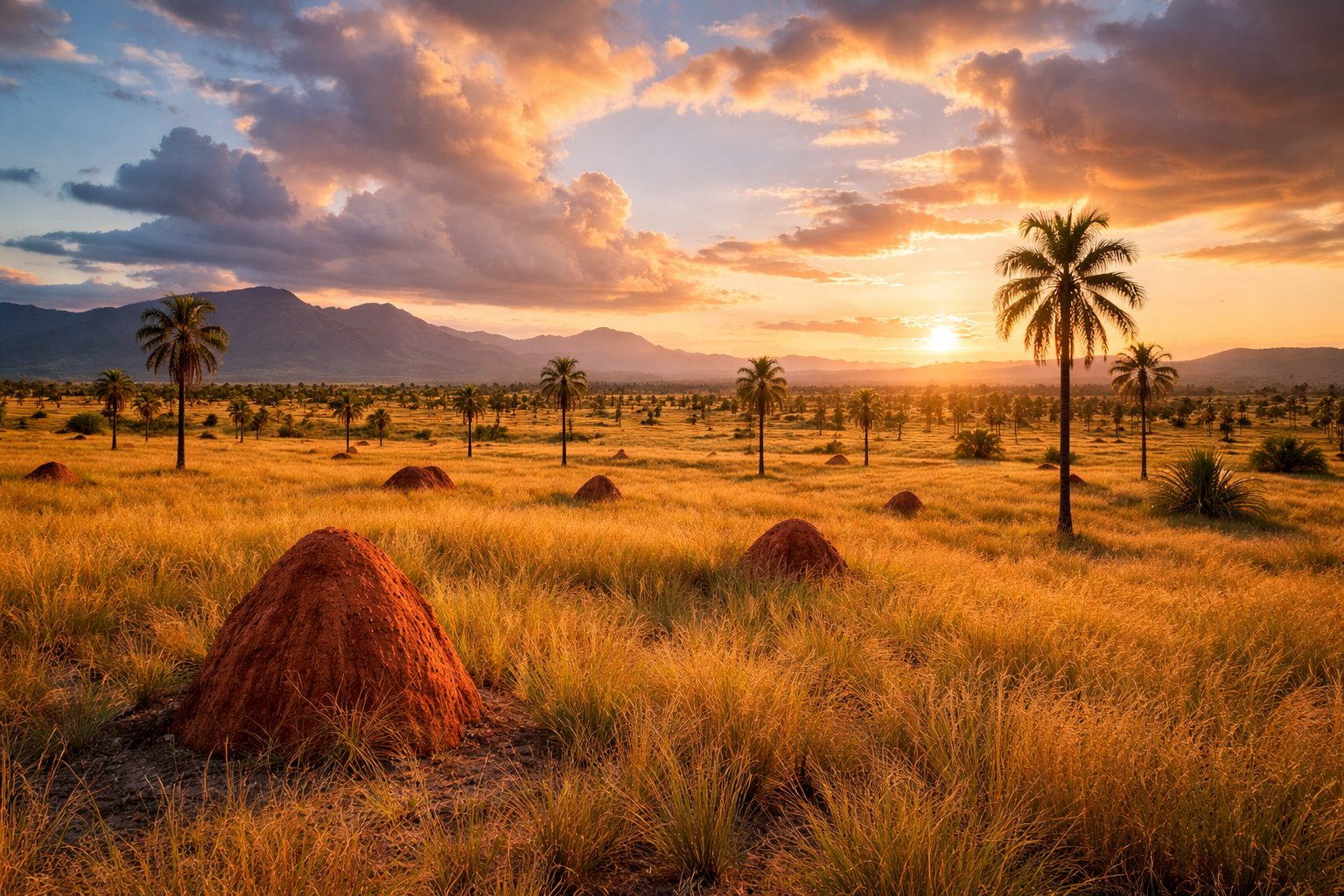
🦎 Rupununi Savanna — Guyana's Wild West
The Rupununi Savanna stretches across southwestern Guyana like a piece of Africa transplanted to South America—vast grasslands punctuated by termite mounds, gallery forests following river courses, and a horizon so distant it seems to curve with the Earth. This is cattle country, vaquero territory, where indigenous Makushi and Wapishana communities have lived for centuries alongside the wildlife that still roams in remarkable abundance.
Wildlife encounters in the Rupununi rival any African safari. Giant anteaters amble across the savanna, capybaras (the world's largest rodent) gather at water sources, and black caiman patrol the rivers. Giant river otters—among the most charismatic and endangered mammals in South America—hunt in family groups on the Rupununi River. Jabiru storks, harpy eagles, and hundreds of other bird species make this a world-class birding destination.
The region divides into North and South Rupununi, connected by a rough road passable only in dry season. Karanambu Lodge, founded by conservation pioneer Diane McTurk, offers giant river otter encounters and comfortable accommodation. Caiman House in Yupukari combines wildlife research with ecotourism. Further south, the remote Wai Wai indigenous community welcomes visitors seeking authentic cultural immersion.
Access requires commitment—either a long drive from Georgetown (12+ hours in dry season, impossible in rains) or charter flights to airstrips serving individual lodges. But for those willing to make the journey, the Rupununi delivers experiences impossible to replicate: riding horses across endless savanna, spotting jaguars at night, fishing for arapaima (the world's largest freshwater fish), and sleeping under stars undiminished by light pollution.
Rupununi Savanna
Endless grasslands and gallery forests — Guyana's wild frontier where giant anteaters roam free
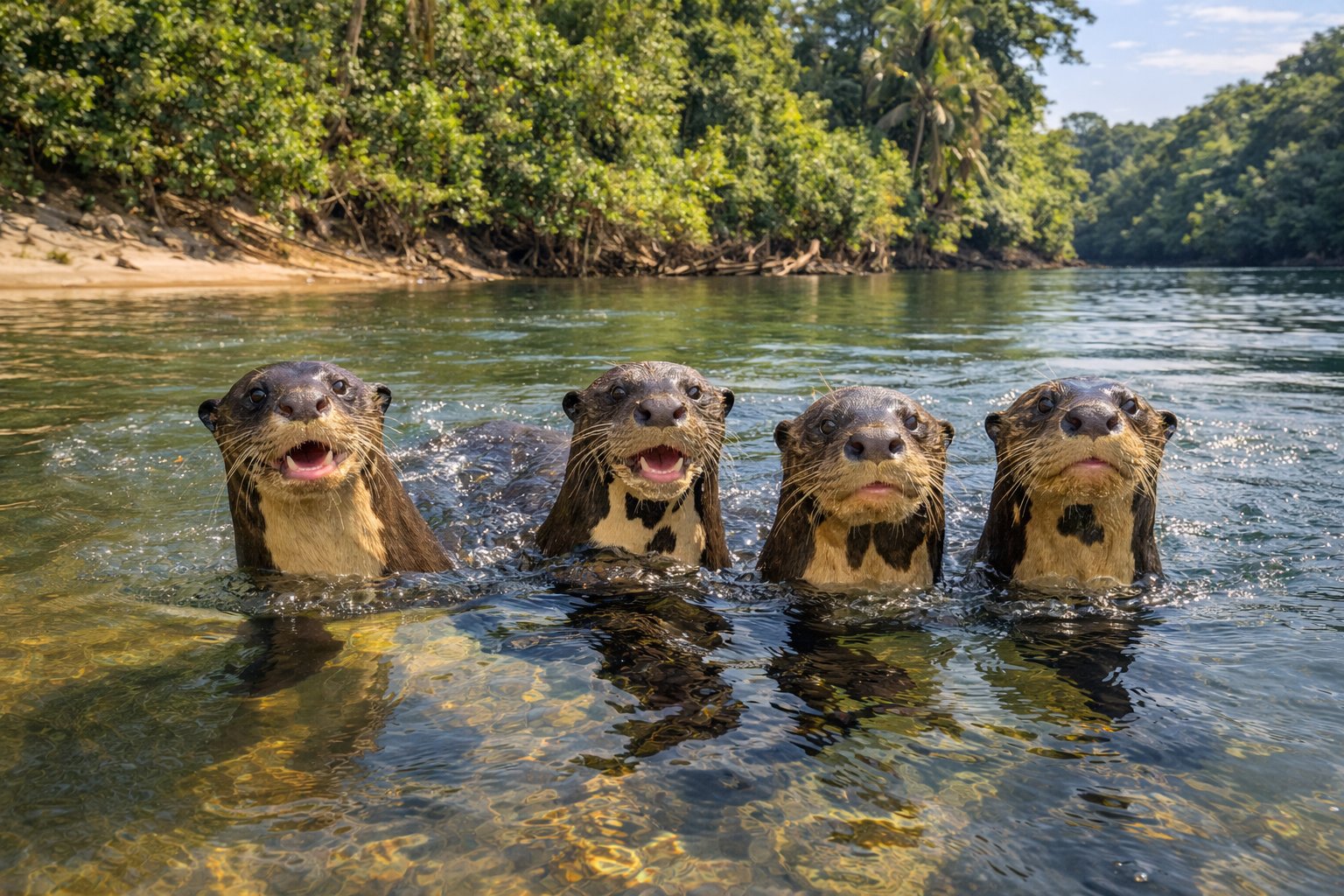
Giant River Otters
A family of giant river otters hunts in the Rupununi — one of the world's most endangered mammals
09
🌳 Iwokrama Rainforest — Jaguar Territory
The Iwokrama Forest sprawls across 371,000 hectares of central Guyana, one of the last pristine tropical rainforests in the world and among the most important conservation areas in the Amazon basin. Established in 1996 as a model for sustainable rainforest management, Iwokrama demonstrates that forests can provide economic benefits while remaining standing—a vital lesson for our warming world.
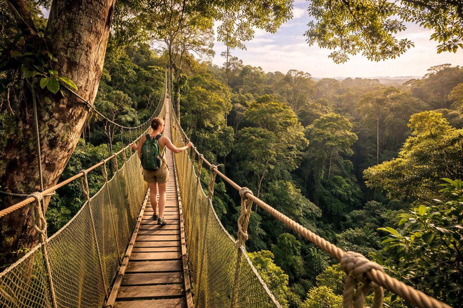
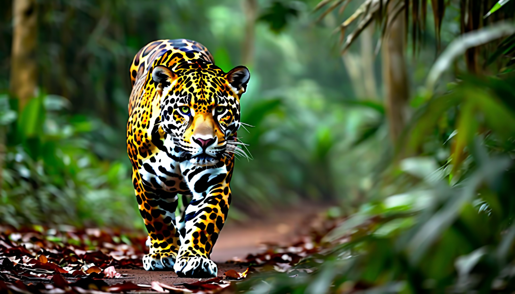
For wildlife enthusiasts, Iwokrama represents one of the best chances on Earth to see wild jaguars. The Iwokrama Canopy Walkway—a series of suspension bridges 30 meters above the forest floor—offers unparalleled perspectives on the rainforest canopy where most biodiversity concentrates. Night drives along the forest roads have become legendary for jaguar sightings, with success rates that rival the Brazilian Pantanal at a fraction of the cost and crowds.
The research station at Iwokrama River Lodge provides comfortable accommodation in the heart of the wilderness. Experienced guides lead forest walks, canoe trips, and night excursions, interpreting a ecosystem that contains over 500 bird species, 500 fish species, and mammals ranging from tapirs to pumas to the elusive jaguar. The lodge's covered deck overlooking the Essequibo River serves as an excellent birding platform at any hour.
Access involves a 7-8 hour drive from Georgetown or charter flights to Annai, followed by boat transfer. The journey itself rewards attention—the road passes through some of Guyana's most spectacular landscapes, and the transition from savanna to deep forest marks entry into one of Earth's great wilderness areas. For travelers seeking immersion in pristine rainforest with scientific credibility and real conservation impact, Iwokrama stands without peer in the Amazon region.
Iwokrama Canopy Walkway
Suspension bridges soar 30 meters above the forest floor — the world's rainforest seen from above
10
🐢 Shell Beach — Sea Turtle Sanctuary
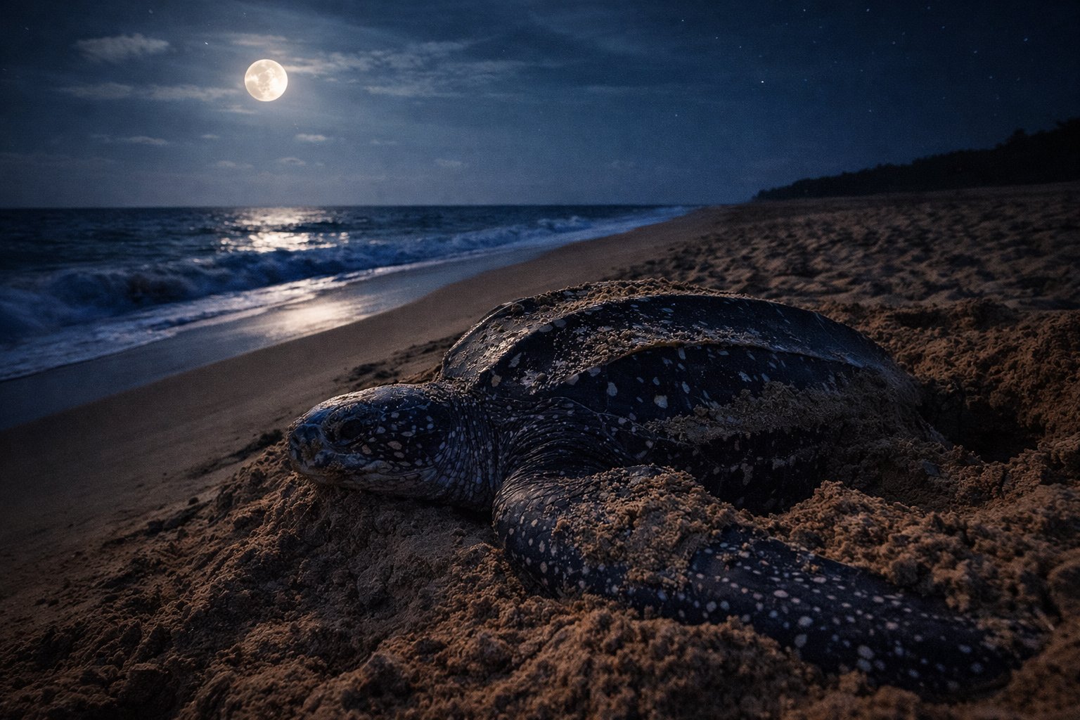
Shell Beach stretches 145 kilometers along Guyana's remote northwestern coast, one of the most important sea turtle nesting sites in the Western Atlantic. Four species—leatherback, green, hawksbill, and olive ridley turtles—return annually to these shores, hauling themselves onto the sand to lay eggs as their ancestors have done for millions of years. This protected area represents conservation success in a region too often defined by habitat loss.
The nesting season runs from March to August, with peak activity in May and June. During these months, visitors can witness one of nature's most moving spectacles: massive leatherback turtles—weighing up to 900 kilograms—emerging from the Atlantic under moonlight, digging nests with their flippers, and depositing over 100 eggs before returning to the sea. The experience of watching this ancient ritual unfold is profoundly humbling.
Access requires dedication. The Guyana Marine Turtle Conservation Society operates a research station at Almond Beach, reachable by boat from Charity or by small aircraft. Accommodations are basic but functional, and the remoteness itself forms part of the experience. Community guides from local Warao indigenous villages accompany all turtle watches, sharing both scientific knowledge and traditional perspectives on these remarkable creatures.
Beyond turtles, Shell Beach supports diverse coastal ecosystems. Scarlet ibis flock to roost at sunset, turning mangrove islands brilliant red. Manatees inhabit the muddy waters, and the beach's extensive shell deposits—giving the area its name—provide habitat for countless invertebrates. For wildlife enthusiasts willing to venture off the beaten path, Shell Beach offers encounters available nowhere else in Guyana.
Shell Beach Sea Turtles
A leatherback turtle returns to the sea after nesting — ancient rituals on Guyana's protected coast
11
🏔️ The Interior — Indigenous Homelands
Beyond the coastal strip and accessible savannas lies Guyana's vast interior—a roadless wilderness of rivers and forests where indigenous communities maintain traditional lifestyles largely unchanged for centuries. Nine distinct Amerindian peoples call this region home, each with unique languages, cultures, and relationships with the surrounding environment.
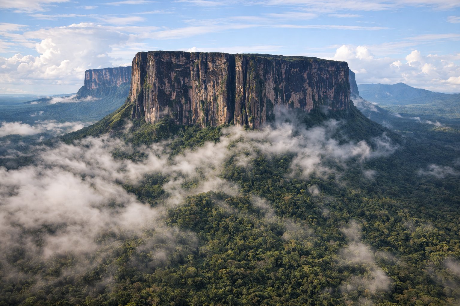
The Pakaraima Mountains rise along the western and southern borders, sharing the famous tepui formations with Venezuela and Brazil. Mount Roraima (2,810m), where the three countries meet, inspired Arthur Conan Doyle's "The Lost World." These ancient table-top mountains, surrounded by sheer cliffs, harbor endemic species found nowhere else on Earth—relics from an era before the surrounding lowlands existed.
Access to the deep interior typically requires bush plane flights to remote airstrips or multi-day boat journeys up rivers that remain the primary highways. The Wai Wai people near the Brazilian border welcome visitors seeking authentic cultural immersion. The Patamona communities near Kaieteur maintain close connections to the falls their ancestors named. Each interaction with indigenous Guyana reveals sophisticated knowledge systems developed over millennia.
For adventurous travelers, expeditions into the interior offer experiences impossible to find in more developed regions: nights in hammocks under jungle canopy, fishing for piranha, tracking wildlife with expert indigenous guides, and witnessing ways of life that connect directly to the deep human past. These journeys require flexibility, patience, and acceptance of basic conditions—rewards proportional to effort invested.
Guyana's Ancient Interior
Tepui mountains rise above endless rainforest — the inspiration for "The Lost World"
12
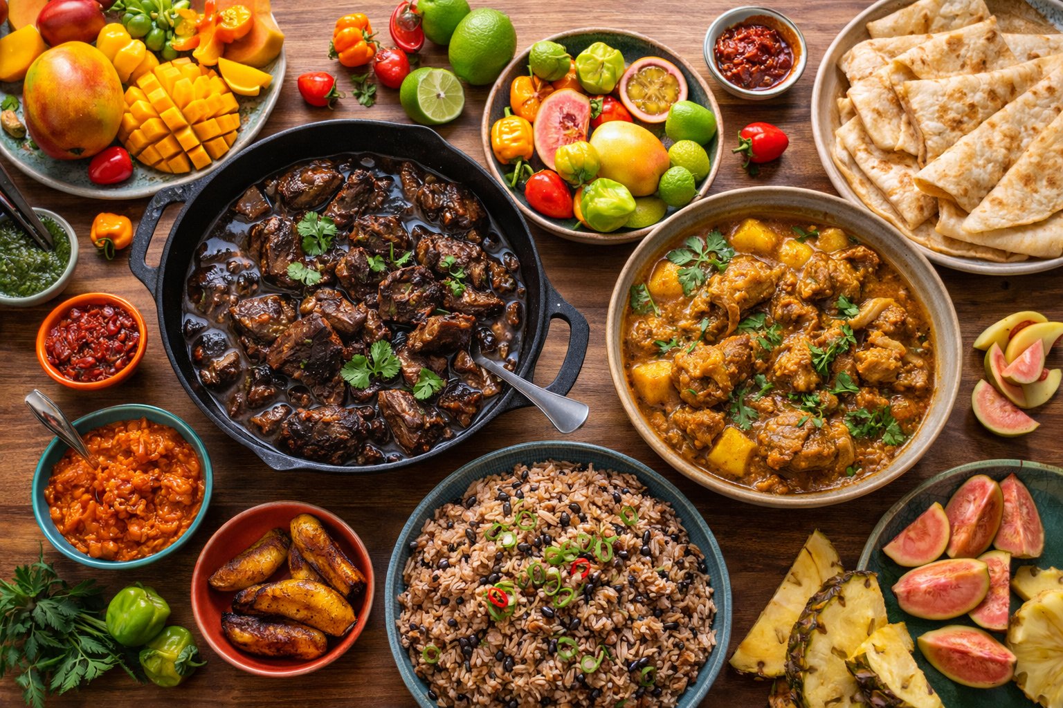
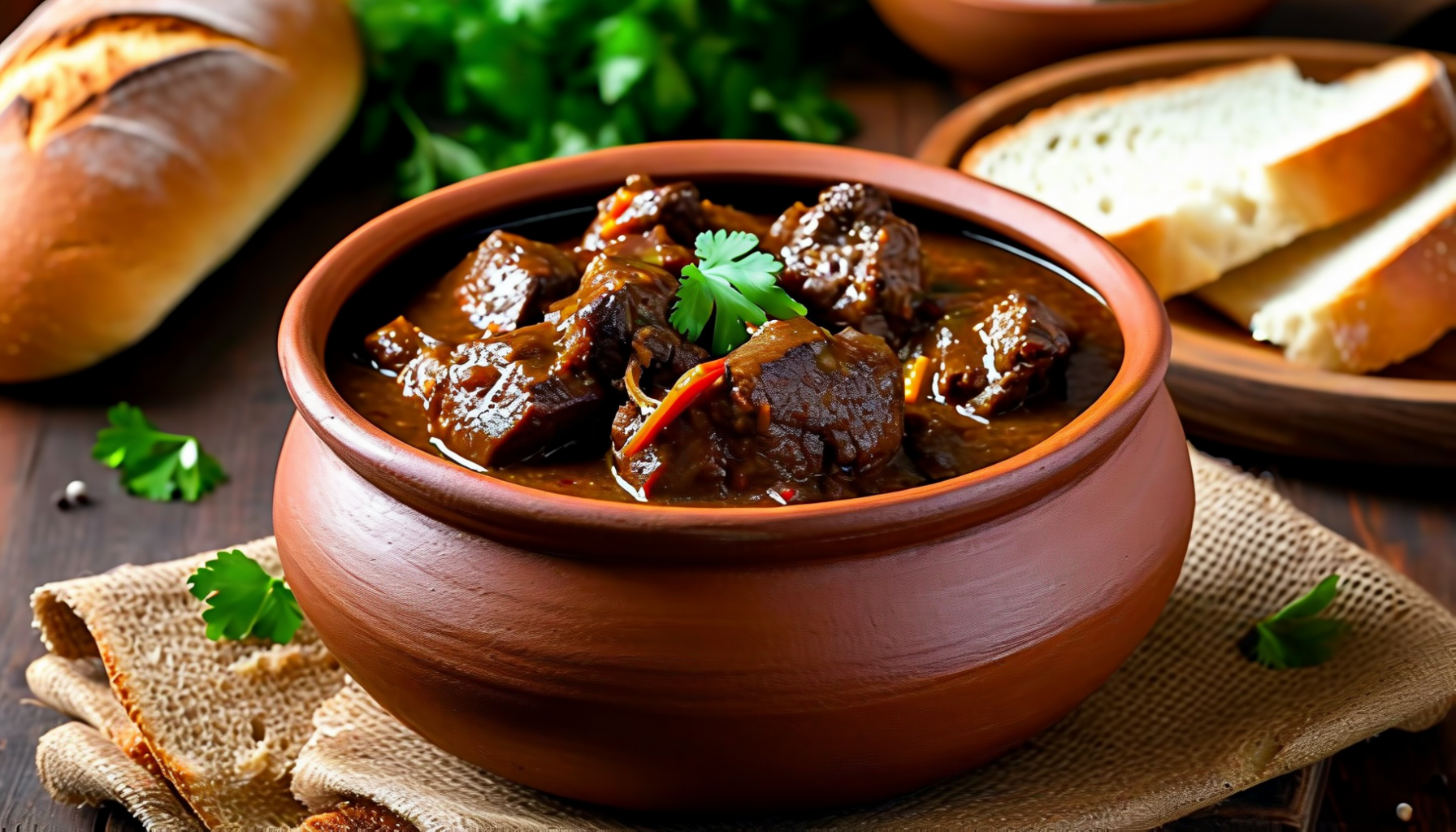
🍜 Cuisine
Guyanese cuisine reflects the country's remarkable ethnic diversity—a fusion of Indian, African, Indigenous, Chinese, Portuguese, and Creole traditions that creates one of the Caribbean's most interesting food scenes. The result is a culinary landscape where curry and roti share tables with cook-up rice and pepper pot, where Chinese chow mein competes with African-influenced metemgee.
Signature Dishes:Pepper Pot – the national dish, a slow-cooked meat stew flavored with cassareep (cassava-based sauce), traditionally served at Christmas but available year-round. Cook-up Rice – rice cooked with beans, coconut milk, and whatever protein is available. Curry & Roti – Indian-influenced curries (chicken, duck, goat, or vegetables) served with soft dhalpuri or paratha roti. Metemgee – African-origin dish of ground provisions in coconut milk with fish.
Beverages:Mauby – bittersweet drink made from tree bark, an acquired taste loved by locals. Rum – El Dorado rums from Demerara Distillers rank among the world's finest. Sorrel – hibiscus drink popular at Christmas. Fresh coconut water – available everywhere from roadside vendors.
Guyanese Culinary Fusion
Curry and roti, cook-up rice, and pepper pot — where Indian, African, and Caribbean flavors meet
📜 Traditional Guyanese Recipes
Bring the flavors of the Caribbean to your kitchen with these authentic Guyanese recipes.
🍖 Pepper Pot — The National Dish
An Amerindian heritage dish traditionally served at Christmas
Ingredients:
2 lbs beef (or mixed meats)
1 cup cassareep
2 cinnamon sticks
6 cloves
Wiri wiri peppers (to taste)
Brown sugar, salt
Instructions:
Cut meat into large chunks
Combine all ingredients in large pot
Simmer slowly for 2-3 hours
Add water as needed
Meat should be very tender
Serve with fresh bread or rice
💡 Tip: Pepper pot improves with age — add fresh meat and cassareep daily. Some families keep pots going for generations!
🍚 Cook-Up Rice — One-Pot Wonder
The ultimate comfort food — rice, peas, and coconut milk
Ingredients:
2 cups rice
1 can pigeon peas or black-eyed peas
1 can coconut milk
Salt fish or salted beef
Thyme, garlic, onion
Pepper to taste
Instructions:
Soak and prepare salt meat
Sauté onion, garlic, thyme
Add peas, coconut milk, water
Add rice and meat
Simmer until rice is cooked
Stir occasionally, don't let it stick!
🫓 Dhalpuri Roti — Stuffed Flatbread
Indian heritage — soft bread stuffed with seasoned split peas
Ingredients:
3 cups flour
1 cup yellow split peas (ground)
Cumin, garlic, pepper
Oil for cooking
Warm water
Salt to taste
Instructions:
Make soft dough, rest 30 min
Cook and season split peas
Stuff dough balls with pea mixture
Roll out carefully
Cook on hot tawa with oil
"Clap" the roti to soften
12b
🍷 Wine, Spirits & Drinking Culture
Guyana has no wine production. The country's equatorial climate — hot, humid, and with heavy rainfall across its vast interior of tropical rainforest and savannah — is entirely unsuited to grape cultivation. There are no vineyards and no viticultural tradition in South America's only English-speaking nation.
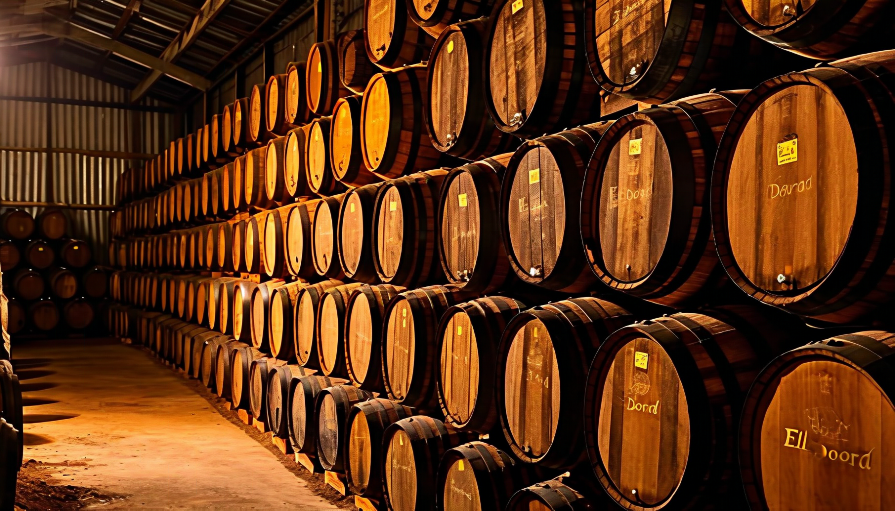
Guyana's contribution to the spirits world is, however, globally significant. Demerara rum — named after the Demerara River and produced at the Diamond Distillery (formerly Demerara Distillers Limited) — is one of the most prized rum styles among connoisseurs. The distillery operates heritage wooden and copper pot stills dating to the 18th and 19th centuries, including the legendary Port Mourant double wooden pot still (c. 1732), producing rums of extraordinary depth and complexity. El Dorado 15-Year and 21-Year are consistently ranked among the world's finest sipping rums. Wine consumption is minimal and entirely import-dependent, with South African and Chilean wines available in Georgetown's hotels and supermarkets.
12c
🍹 Cocktails & Mixed Drinks
Guyana's rum heritage makes it a natural cocktail destination. El Dorado Demerara rums form the backbone of some extraordinary drinks.
🥃 Demerara Rum Punch
The quintessential Guyanese party drink: "One of sour, two of sweet, three of strong, four of weak."
Ingredients: 60ml El Dorado 5-Year rum, 30ml fresh lime juice, 60ml simple syrup, 120ml water or coconut water, dash of Angostura bitters, freshly grated nutmeg
Method: Combine rum, lime juice, simple syrup, and water in a shaker with ice. Shake vigorously, strain into a tall glass filled with ice. Top with Angostura bitters and freshly grated nutmeg.
🍹 El Dorado Swizzle
A tropical tiki classic built around Guyana's finest aged rum.
Method: Pour all liquid ingredients into a tall glass. Fill with crushed ice and swizzle until the glass frosts. Top with more crushed ice, dash bitters on top, garnish with fresh mint.
🥥 Rum & Coconut Water
The simplest and most refreshing drink in the country.
Ingredients: 60ml El Dorado 5-Year or Banks DIH XM rum, fresh coconut water from a green coconut, squeeze of lime
Method: Pour rum into a freshly cracked green coconut. Add a squeeze of lime. Best enjoyed in a hammock at sunset in the Rupununi.
🌺 Mauby Rum Cooler
A uniquely Guyanese creation blending bark-brewed mauby with local rum.
Ingredients: 45ml El Dorado 8-Year rum, 120ml mauby, juice of half a lime, ice, cinnamon stick
Method: Brew mauby by boiling mauby bark with cinnamon, anise, and sugar, then strain and chill. Combine cold mauby with rum and lime juice over ice. Garnish with a cinnamon stick.
13
🌡️ Climate & Best Time to Visit
Guyana has a tropical maritime climate with two wet and two dry seasons. Temperatures remain consistently warm year-round, with the coast moderated by trade winds and the interior experiencing higher extremes. Humidity is high throughout the year, averaging 70-80%.
Season
Temperature
Conditions
Rating
Short Dry (Feb-Apr)
24-32°C
Less rain, good wildlife viewing, easier travel
✅ Excellent
Long Rains (May-Jul)
24-30°C
Heavy rains, interior travel difficult
⚠️ Challenging
Long Dry (Aug-Nov)
24-34°C
Best conditions, turtle nesting, clear skies
✅ Best overall
Short Rains (Dec-Jan)
23-30°C
Moderate rain, Christmas festivities
✅ Good
Best Time:September-November offers the best combination of dry weather and wildlife viewing. February-April is also excellent. Avoid May-July if planning interior travel, as dirt roads and airstrips become impassable. Sea turtle nesting peaks March-August.
14
✈️ How to Get There
By Air: Cheddi Jagan International Airport (GEO) near Georgetown receives flights from Miami (American Airlines, 4.5 hours), New York (Caribbean Airlines via Trinidad), Toronto (Caribbean Airlines, 6 hours), and multiple Caribbean destinations. Local carrier TransGuyana operates domestic flights to interior destinations including Kaieteur, Lethem, and Karanambu.
From Neighbors: Land border with Brazil at Lethem (connect to Boa Vista); expect rough roads in rainy season. Ferry service to Suriname via Moleson Creek. Venezuelan border effectively closed due to ongoing territorial dispute over Essequibo region.
Interior Access: Small aircraft (Cessna 206/208) essential for reaching most interior lodges. Book through Wilderness Explorers, Rainforest Tours, or lodge operators. Flights operate from Ogle Airport near Georgetown. Weather can delay flights—build flexibility into schedules.
Getting Around Georgetown: Minibuses and route taxis serve the city cheaply but chaotically. Licensed taxis available—agree fares before boarding. Ride-hailing apps not widely used. Car rental available but Georgetown traffic is challenging.
15
📋 Practical Information
Visa: Citizens of USA, Canada, UK, EU, and most Commonwealth countries receive visa-free entry for 90 days. Passport must be valid for 6 months. Extension possible through Immigration Department.
Money: Guyanese Dollar (GYD). USD widely accepted at ~210 GYD per dollar (check current rates). ATMs available in Georgetown but unreliable elsewhere—bring enough cash for interior trips. Credit cards accepted at major hotels and some restaurants.
Communications: Digicel and GTT provide mobile coverage. 4G in Georgetown, limited elsewhere. International SIMs may not work—buy local. WiFi at hotels but slow. Time Zone: UTC-4 (same as Eastern US during standard time).
Health: Yellow fever vaccination required if arriving from endemic country. Malaria risk in interior—take prophylaxis. Drink bottled water. Medical facilities limited outside Georgetown—evacuation insurance essential. St. Joseph Mercy Hospital is Georgetown's best option.
Safety: Georgetown has crime issues—avoid walking at night in unfamiliar areas, don't flash valuables. Interior is generally safe but requires proper preparation. Heed advice from lodge operators and guides.
16
💰 Cost of Living
Item
Cost (USD)
Budget guesthouse (Georgetown)
$30-50/night
Mid-range hotel
$80-150/night
Interior lodge (all-inclusive)
$200-400/night
Local meal (roti shop)
$3-8
Restaurant dinner
$15-40
Banks Beer (local)
$2-4
El Dorado Rum (bottle)
$15-40
Kaieteur day trip (flight)
$250-350
Minibus ride (Georgetown)
$0.50-1
Georgetown is affordable for daily expenses, but interior ecotourism is expensive due to flight costs. Budget $100-150/day for Georgetown-based travel, $300-500/day for interior packages including flights and lodges.
17
🏨 Accommodation
Guyana's accommodation ranges from Georgetown city hotels to remote jungle lodges accessible only by small plane. The interior lodges—often the highlight of any Guyana trip—typically operate all-inclusive packages including flights, meals, and guided activities.
Georgetown: Marriott (international standard, $150-250), Cara Lodge (historic colonial charm, $120-180), Pegasus (business hotel, $100-150), Status International ($60-90), numerous guesthouses ($30-60).
Booking Tips: Book interior lodges well in advance, especially September-November peak season. Most require deposits. Georgetown hotels bookable online through standard platforms. Wilderness Explorers and Rainforest Tours package multiple lodges efficiently.
18
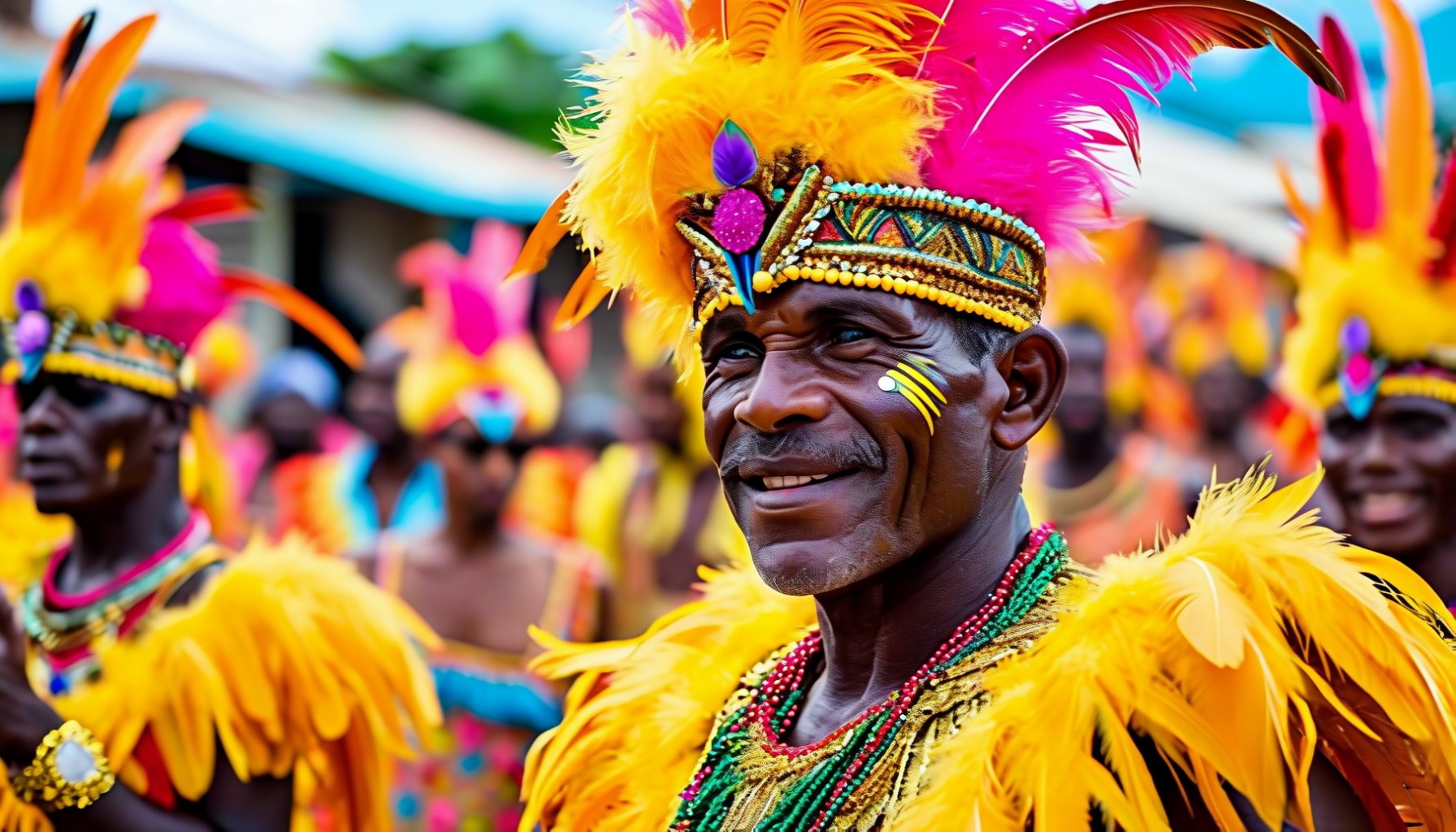
🎭 Festivals & Events
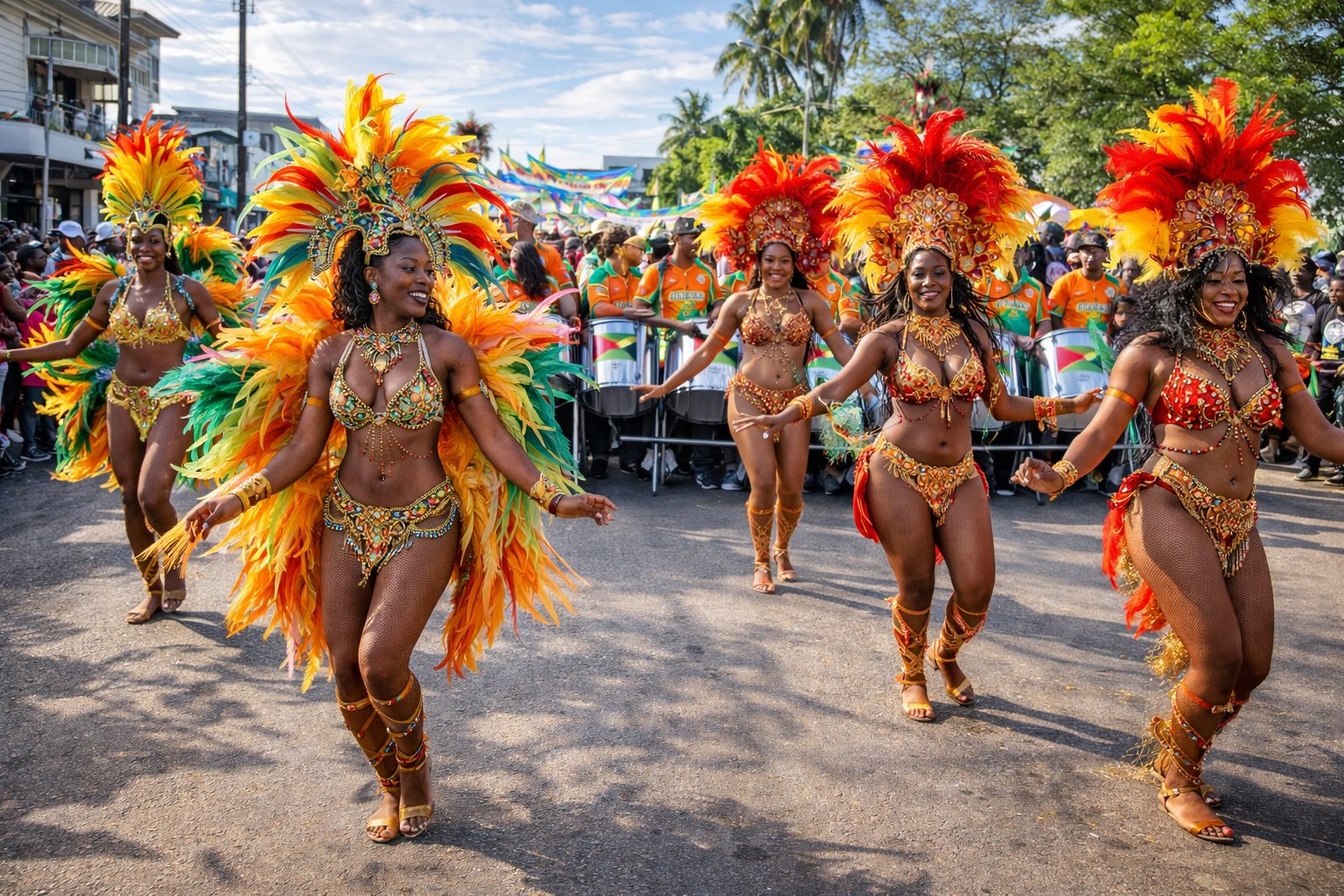
Mashramani (February) — Guyana's Carnival and Republic Day celebration combined. Colorful parades, steel bands, and costume competitions flood Georgetown's streets. "Mash" as locals call it features traditional masquerade characters and Caribbean revelry. Phagwah/Holi (March) — The Hindu festival of colors takes over the country. Everyone—regardless of religion—joins in throwing colored powder and water.
Diwali (October/November) — Festival of lights brings clay diyas (lamps) to homes across the country. Hindu temples hold special celebrations, and the entire nation enjoys the holiday. Independence Day (May 26) — Military parades and national celebrations mark independence from Britain in 1966. Christmas — Pepper pot is served, churches fill, and the coast comes alive with celebrations blending Christian traditions with Caribbean culture.
Mashramani — Guyana's Carnival
Colorful costumes and steel bands flood Georgetown's streets during Guyana's biggest celebration
19
💎 Hidden Gems
Marshall Falls — Smaller than Kaieteur but equally beautiful, this waterfall near Mahdia offers a less crowded alternative with swimming opportunities. Rewa Eco-Lodge — Community-run lodge on the Rewa River, famous for arapaima (world's largest freshwater fish) catch-and-release fishing and pristine wildlife viewing.
Berbice River — Less visited than the Essequibo, the Berbice offers excellent birdwatching and access to remote Amerindian communities. Bartica — Historic gold-mining town at the confluence of the Essequibo and Mazaruni rivers, gateway to waterfalls and interior expeditions. Mabaruma — Remote northwestern town offering access to indigenous Warao communities and unique ecosystems.
19b
🏛️ UNESCO World Heritage
Guyana currently has no inscribed UNESCO World Heritage Sites, making it one of a handful of countries still awaiting its first designation. However, the nation has submitted five properties to its Tentative List, signaling future ambitions:
🏛️ Georgetown's Plantation Structure and Historic Buildings
The capital's distinctive Dutch-British colonial architecture, including wooden buildings on stilts, the Stabroek Market, and the grid-pattern layout reflecting its plantation origins.
⛪ St. George's Anglican Cathedral
One of the tallest wooden buildings in the world at 43 meters. Built between 1889-1892 in Gothic Revival style using greenheart timber, it is an engineering marvel.
🏰 Fort Zeelandia & Court of Policy Building
Dutch colonial-era fortifications dating to the early settlement of Essequibo, representing the earliest European presence in Guyana.
🏛️ City Hall, Georgetown
A magnificent Gothic Revival structure completed in 1889, considered one of the finest examples of Victorian architecture in the Caribbean.
🐢 Shell Beach (Almond Beach), Essequibo Coast
A 140km stretch of pristine coastline that serves as a critical nesting site for four species of endangered sea turtles, including the leatherback, green, hawksbill, and olive ridley.
Kaieteur Falls and the Iwokrama Rainforest — both extraordinary natural landmarks — are notable absences from the Tentative List and are frequently cited by conservation organizations as deserving of World Heritage status.
20
🎒 Packing Tips
Essential: Passport valid 6 months, cash in USD and GYD (ATMs unreliable outside Georgetown), travel insurance with evacuation coverage, copies of all documents, unlocked phone for local SIM, power adapter (Type A/B, 110V/240V).
Clothing: Light, breathable fabrics for tropical heat. Long pants and sleeves for mosquitoes in interior. Rain jacket essential. Good walking boots for jungle treks. Swimwear for waterfalls and rivers. Hat and sunglasses. Health: Strong insect repellent (DEET or Picaridin), sunscreen, anti-malarial medication, basic first aid, water purification tablets.
Interior Trips: Headlamp, binoculars for wildlife, waterproof bags for electronics, minimal luggage (small planes have weight limits—typically 25 lbs), camera with good zoom. Leave valuables in Georgetown hotel safe.
21
🌐 Useful Resources
Embassy: US Embassy Georgetown +592-225-4900 | British High Commission +592-226-5881/4. Emergency: Police 911, Ambulance 913, Fire 912. Medical: St. Joseph Mercy Hospital +592-227-2072.
Non-Fiction: "The Wild Coast" by John Gimlette — engaging account of travels through the Guianas. "Thunder in Guyana" by Martin Carter — poetry capturing the national spirit. "A History of Guyana" by Cheddi Jagan — by the country's independence leader and former president.
Fiction: Works by Wilson Harris, Guyana's most acclaimed novelist. "Palace of the Peacock" explores the interior with mythical intensity. Edgar Mittelholzer's "Corentyne Thunder" captures plantation life. Online: Stabroek News (daily newspaper) and Kaieteur News for current affairs.
23
🎬 Videos About Guyana
Discover Guyana through these carefully selected documentaries and travel videos. From Kaieteur Falls to jaguar encounters in the rainforest, these films capture the country's wild beauty.
A permanent rainbow arcs through the mist as the Potaro River plunges 226 meters into the ancient gorge
💧 Kaieteur Falls — Nature's Raw Power
Deep in Guyana's Potaro-Siparuni region, Kaieteur Falls plunges an astonishing 226 meters in a single drop—five times the height of Niagara Falls and nearly twice Victoria Falls. What makes Kaieteur truly exceptional is the combination of height and volume, making it arguably the world's most powerful single-drop waterfall.
The falls were named after Chief Kai, a Patamona leader who, according to legend, paddled over the edge in a canoe to appease the great spirit Makonaima and save his people from enemy tribes. The word "teur" means falls in Patamona, so Kaieteur literally means "Kai's Falls."
The plateau surrounding the falls hosts unique wildlife including the tiny golden frog (Anomaloglossus beebei), which breeds exclusively in the giant tank bromeliads growing on the cliff edges. The white-tipped swift (Aeronautes montivagus) nests behind the waterfall itself, flying through the crushing curtain of water daily.
226m
Single Drop Height
5×
Niagara's Height
1870
Year Discovered
~20
Visitors Per Day
🛢️ Oil Bonanza
Since 2019, Guyana has become one of the world's newest oil producers. By 2027, production is expected to exceed 1 million barrels daily, potentially making this small nation wealthier per capita than Saudi Arabia. The challenge: ensuring wealth benefits all citizens.
🌳 85% Forest Cover
Guyana maintains one of the highest forest coverage rates on Earth. The country pioneered forest-for-payment conservation programs, receiving international compensation for keeping trees standing. This pristine rainforest stores billions of tons of carbon.
🏏 Cricket Obsession
Despite being in South America, Guyana is cricket-mad. The country has produced legendary players including Clive Lloyd and Shivnarine Chanderpaul. The Providence Stadium hosts international matches, and cricket discussions dominate casual conversation.
🦦 Giant River Otters
Guyana's rivers harbor the endangered giant river otter—the world's longest otter at up to 1.8 meters. Highly social and vocal, these charismatic predators hunt in family groups and are best seen at Karanambu Lodge in the Rupununi.
25
⭐ Notable People
Cheddi Jagan (1918-1997) — Independence leader, three-time Prime Minister, and President. Jagan championed workers' rights and led Guyana to independence. His widow Janet Jagan later became President. The international airport bears his name.
Wilson Harris (1921-2018) — One of the Caribbean's most acclaimed novelists. "Palace of the Peacock" is considered a masterpiece of magical realism. His experimental prose explored Guyana's interior as both physical and metaphysical landscape.
Sports: Clive Lloyd — legendary cricket captain who led West Indies to two World Cup victories; Shivnarine Chanderpaul — one of cricket's most durable batsmen with 11,000+ Test runs; Rohan Kanhai — stylish batsman considered one of the finest to represent the West Indies.
Eddy Grant (b. 1948) — Born in Plaisance, this reggae/pop legend gave the world "Electric Avenue," "I Don't Wanna Dance," and the anti-apartheid anthem "Gimme Hope Jo'anna." He owns a recording studio in Barbados and remains one of the most commercially successful artists of Caribbean origin.
Walter Rodney (1942-1980) — Historian, political activist, and Pan-Africanist intellectual. His seminal work "How Europe Underdeveloped Africa" remains essential reading in postcolonial studies. Assassinated in Georgetown by a car bomb at age 38, he is a martyr of Guyanese politics.
Martin Carter (1927-1997) — Guyana's greatest poet. His collection "Poems of Resistance from British Guiana" inspired the independence movement. Lines like "I do not sleep to dream, but dream to change the world" are etched into the national consciousness.
Forbes Burnham (1923-1985) — Co-founder of the People's National Congress, first Prime Minister and later President. A controversial figure who led Guyana to independence but whose later years were marked by authoritarian rule. His vision of cooperative socialism shaped the nation's post-independence identity.
26
⚽ Sports
Cricket: Guyana's national obsession. The country has produced legendary players including Clive Lloyd, Shivnarine Chanderpaul, and Ramnaresh Sarwan. Providence Stadium in Georgetown hosts international matches, and the Guyana Amazon Warriors compete in the Caribbean Premier League. Match days effectively shut down the country.
Football: Growing in popularity, with the national team (Golden Jaguars) competing in CONCACAF qualifiers. Athletics: Guyanese-heritage athletes have excelled internationally, including sprinter Aliann Pompey and boxer Andrew Lewis. Traditional Sports: Horse racing remains popular in the Rupununi, where vaquero culture thrives.
27
📰 Media & Press Freedom
Guyana has a relatively free press by regional standards. Major newspapers include Stabroek News (independent), Kaieteur News, and Guyana Chronicle (government-affiliated). Television channels include NCN and private broadcasters. Radio remains important for reaching interior communities.
Challenges: Limited media training, financial pressures, and occasional political interference remain concerns. International observers note improving press freedom since democratic consolidation in the 1990s. Social media is increasingly influential, particularly Facebook.
28
📸 Photo Gallery
Share your Guyana photos! Send to photos@kaufmann.wtf to be featured.
Kaieteur Falls
The world's mightiest single-drop waterfall
Georgetown Cathedral
One of the world's tallest wooden buildings
Rupununi Savanna
Endless grasslands at golden hour
Giant River Otters
Charismatic predators of the Rupununi
Iwokrama Rainforest
Canopy walkway above the jungle
El Dorado Distillery
Heritage rum-making on the Demerara River
Stabroek Market
Georgetown's iconic iron market hall
Mashramani Carnival
Republic Day celebrations in February
Sea Turtle Nesting
Leatherback turtles at Shell Beach
Pepperpot
Guyana's beloved national dish
Jaguar Encounter
Apex predator of the Iwokrama
29
✍️ Author's Note
Guyana is not a destination for those seeking easy comfort. The interior demands effort—small planes to remote airstrips, boats through jungle rivers, nights without electricity or running water. Georgetown itself can feel challenging with its chaotic traffic, sporadic infrastructure, and security concerns. But for travelers willing to embrace these realities, Guyana delivers experiences impossible to find elsewhere.
Standing alone at Kaieteur, with no crowds and no guardrails, watching the Potaro River launch into void—this is travel stripped to its essence. Watching giant otters hunt in the Rupununi, spotting jaguars on night drives, sharing pepper pot with a Makushi family—these experiences reward patience and planning. Guyana is South America's last frontier, a place where wilderness still means wilderness, and where the reward is proportional to the effort.
"Land of Many Waters" — One People, One Nation, One Destiny
—Radim Kaufmann, 2026
Support This Project 🌍
This World Travel Factbook is a labor of love – free to use for all travelers. If you find it helpful, consider supporting its continued development.